 Adventure Pilot’s portable moving-map GPS features vertical flight planning and a terrain warning system with audible alerts. |
If you could buy a sunlight-readable, multifeatured, portable moving-map GPS for VFR and IFR flight, with an excellent automobile GPS, that also played your music, audio and video files, and connected to the Internet via WiFi, would you hesitate to spend $749 for that unit?
Two years ago, I came across a new avionics company: Adventure Pilot. Headed up by two superbright, hard-working guys—Walter Boyd and Shane Woodson—their first effort was a feature-rich Everyman’s “supplemental” (not FAA-certified) navigational GPS, the iFly 700. It was a runaway success at $500 (comprehensive software/data subscription package/year: $69, or full IFR: $109).
Two striking features of the 700 (which remains in production at $549, or $599 with iFly Streets, the automobile GPS program) were the touch-screen and FAA sectional moving-map display. Pilots could literally touch airport symbols on the Sectional to set waypoints and create an instant magenta course line. They could also “rubber-band” that course line by dragging it to any additional waypoints desired along the route, or tap any airport, restricted area, obstruction etc. for instant, on-map detailed information.
The seven-inch unit was simple to use, yet beneath its user-friendly interface, layers of dialogs waited to satisfy even the most fanatical detail-crazed pilot. Now comes the iFly GPS 720 and powerhouse Version 7 software update (also for iFly 700). The new unit is faster, more powerful, with enough new navigation features to make your head spin:
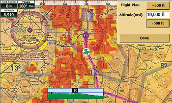
â¢âTerrain/Obstructions Display. Color highlighting of terrain and obstructions for all displays (ADS-B collision avoidance, too!) User-configurable alert system.
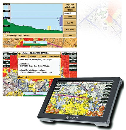
â¢âActive Alert System. Advanced collision-avoidance capability constantly monitors current and projected AGL with adjustable tolerance levels. Says Walter Boyd, “We even use FAA-defined audible call outs.” Trust me: The loud “TERRAIN! TERRAIN!” callouts get your attention pronto.
â¢âVertical Flight Planning. The new Version 7 update comes with a terrific display feature: a profile graphic of your flight path, the terrain en route, airspaces, obstacles, aircraft performance and winds aloft. It’s visually intuitive, easy to manage, and customizable.
â¢âiFly Connect. The most hassle-free software updater I’ve ever used for any computer program, period. Details below.
 |
â¢âDirect-To Function On The Flight Plan Page. Instant updating of your flight plan and saved previous waypoints. Imagine you diverted off course 30 miles to photograph Hoover Dam. To resume your course, touch the Direct-To button of your final destination, and a new course line draws. But the waypoint over Hoover Dam remains saved in the flight plan for future reference. A pending update will allow you to name any waypoint on the fly! How useful is that?
â¢âFlight Timer. Automatically stops recording en route time when forward speed drops below 15 knots. It’s perfect for weather/fuel/food landings.
Bonus Round
Although introduced on the 700 model months ago, iFly Streets deserves some ink. A fully functional street navigator, complete with turn-to-turn voice guidance, it’s a snap to take overseas, since you “rent” and download foreign nav data just for the period you’re traveling.
Adventure Pilot’s partner iGO Navigation supplies the software, already deployed on 30 million mobile and Windows devices around the world. Updates are included in all iFly update packages: that could save you more than the entire subscription service alone!
Shane Woodson says helicopter pilots use iFly Streets for referencing locations in hard-to-identify urban environments. I gave iFly Street a spin in my car without reading a word of the manual: user friendly as can be. The big seven-inch screen is a bonus, too.
Back to the aviation side. A new, more intuitive opening page offers quick access to the five main menu items: Navigation, iFly Streets, Music, Movie and an analog clock.
A tidy, scrollable menu accesses setup and update options, Internet access (WiFi is included on the 720!), easy updates through WiFi, even convenience features like memo pad, TextViewer, AV-In (camera video monitor etc.), calculator and for those with way too much free time, a solitaire game.
More on iFly Connect updater: Just download the small app to your home PC/laptop (Windows XP, Vista or 7 only), plug the unit’s SD card into your computer’s card reader, launch the program, click update…and take a coffee break. iFly Connect goes online, compares your iFly data with the latest versions, then automatically updates and installs only what you need!
You can update on the go too. Just ask the FBO to install the iFly Connect app—updates aren’t keyed to a specific computer.
iFly models are ready for ADS-B Nexrad weather too. Also planned for the version 7.5 update, expected upon publication, is an instrument panel page and portrait display mode.
“Air Gizmo,” Shane Woodson says, “makes a panel dock for both the 700 and 720, so someone with a certified or experimental airplane can drop the iFly right into it for a clean, flush install.”
The iFly doesn’t have a built-in battery (car and wall plugs come with the units). The Air Gizmo has a built-in slot for aftermarket external battery packs, needed if you don’t have a panel cigarette DC power socket.
Airport diagrams show your location in real time…great for navigating to unfamiliar ground locations. And consider the advantage of one inexpensive data subscription package over multiple subscriptions for various software packages (iPadders, are you listening?). Also, unlike iPad apps, the iFly GPS function doesn’t require a current subscription for expired charts or data to remain operational (although we recommend you fly with current data).
Finally, wondering about using touch-screen GPS in turbulent conditions? Woodson says, “We use a ‘resistive screen,’ preferred for aviation and military uses. It’s also more durable, lets pilots use gloves, is pressure sensitive and allows accidental rapid taps caused by turbulence to be ignored by our software. We don’t use toss panning either (rapid page flicking a la iPhone, iPad), due to its problematic behavior in a turbulent cockpit.”
And for those really bumpy days, Woodson adds: “We include a remote control that lets you perform most functions and chart exploring, even simple Flight Planning and modifications.”
If owning a portable, moving-map GPS for VFR and IFR that’s wonderfully affordable without compromising advanced power and functionality is on your wish list, give the iFly 720 (and 700) a real checkout.
Visit www.iflygps.com.


