
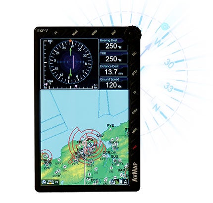
 AvMap’s EKP-V has an excellent high-contrast color display with a very wide viewing angle. |
When we looked at AvMap’s EKP-IV back in 2004, we described it as “the Rolls Royce of portable GPS units,” with better features than the competition at a higher price. The EKP-V, announced last year, expands on that; by default, it’s a very competent handheld GPS navigator, and with one of two optional docking stations, it may function effectively as a full-blown EFB, depending on your airplane and equipment.
By itself, the EKP-V measures 4.3×6.8×0.8 inches and weighs 14 ounces. It has an excellent, high-contrast seven-inch diagonal TFT color LCD display with a very wide viewing angle. Brightness is adjustable (in the System Setup menu) and goes from pretty dim to bright enough to overpower direct sunlight, though the high-gloss screen surface can produce glare in some orientations. Nice touches for those who fly in the dark include a night palette that minimizes background glare and luminescent buttons on the 10 bezel buttons (one user programmable), which—along with a unique
joystick and dial—provide the EKP-V’s user interface, which takes a little getting used to but feels quite natural with practice. We particularly like AvMap’s approach to entering waypoints, using the dial and a circular on-screen presentation of letters and/or numbers and other symbols. And unlike earlier models, along with a 12-volt cigarette-lighter adapter, the EKP-V has a built-in battery with substantial capacity—it still showed a 60% charge after several hours of continuous use in our tests.
The EKP-V’s built-in software and data-bases (which can be updated online from a desktop or notebook PC with a USB port) provide GPS navigation with WAAS (or the European EGNOS equivalent), moving map, simulated horizontal situation indicator and vertical terrain profile functions. By default, the map shows a terrain view with both aviation and terrestrial overlays; pressing the Cycle button removes terrestrial data from the map. You can customize the map to remove terrain shading and provide TAWS if you prefer.
The database is extensive, including (among other things) worldwide airports and navaids from Jeppesen, and terrestrial data and street maps by NavTeq. While the EKP-V isn’t TSO certified for IFR use, FAA plates and diagrams are provided for U.S. airports, and the display shows an airplane symbol so you can see exactly where you are on the procedure.
We weren’t able to evaluate what may be the EKP-V’s most unusual feature: With the higher end of two optional panel docks, it can interface with a wide range of devices, including weather, traffic—and unique for GPS navigators in this class—some autopilots. That caused quite a stir when announced at last year’s AirVenture, but as this is written, neither dock was available. An AvMap representative told us that more information will be available soon, and both should be available for sale by the end of the year. He also told us that the high-end version with autopilot support is aimed at the light-sport and experimental market. In the meantime, the EKP-V ships with a plastic adapter curved to fit the average pilot’s thigh that snaps on the back of the unit. Add a Velcro strap, and it makes a neat and effective electronic kneeboard.
I have one complaint about the EKP-V, which is the documentation: Like all too many avionics vendors, AvMap no longer provides a printed manual. Instead, the EKP-V comes packaged with a CD from which you download a PDF that can be printed out. I strongly recommend doing so—it won’t take too much paper, as what AvMap calls the “Quick User Manual” is just 20 pages, which is inadequate. If AvMap is serious about competing with Garmin for the high-end portable aviation GPS market, they’ll need to improve.
Pricing for the EKP-V starts at $1,998. For more information, visit www.avmap.us.