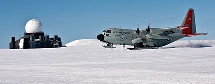
 The 109th Airlift Wing of the New York Air National Guard trains for polar missions in an LC-130 on the remote 6,251-foot skiway at Camp Raven, in the vastness of the Greenland ice cap. The DYE-2 radar site was part of the Distant Early Warning Line built during the Cold War to protect the United States against an attack. It was evacuated overnight in 1987; all equipment, books and furniture still remain inside the abandoned structure. |
“The skiway is in good shape. We’ve had good grooming, and the past four nights, temps have been below minus-10 degrees C, which helps firm up the newly worked surface. Be advised that the afternoon temps have been very warm and cook the surface into wet soft slush. These conditions could cause deep ruts in the skiway and inhibit takeoffs. Open snow conditions are quite firm in the morning and almost seem ‘rotten’ in the warmth of the day. Both Mark and Lou will be available to help with operations on the ground and/or on the radio—please just let us know. Camp Raven outgoing cargo for the week: LMC tractor (9,000 pounds), 4 MT coolers, U.S. mail, books, towels.”—Camp Raven Skiway Report, 23 June 2008
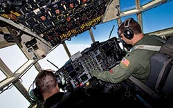
The horizon is overrated,” quips Major Bryan Elsworth from the right seat of the LC-130. I think he’s joking, but I’m not positive. As we descend through an overcast layer at 1,000 feet AGL, the sapphire Arctic sky pales to white. Below, the ice sheet that covers more than 80% of Greenland is featureless and so white that I’m unable to discern when we’ve emerged below the clouds. Visibility is actually two miles, but the view out the cockpit is that of near whiteout conditions due to the void of visual references and poor surface definition. “It’s like night flying when it’s hazy, and you can see a few stars above, a few lights below, but almost no horizon,” says Major Frank Falvo. “The difference is everything is white instead of black. It’s what we call flying inside of a ping-pong ball.”
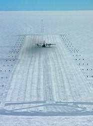 Camp Raven appears as a tiny black speck barely perceptible on the immense ice cap. Lacking any other visual ground references, depth and distance perception can be deceiving. A typical Greenland season for the 109th averages 850 flight hours, 1.4 million pounds of cargo, 60,000 gallons of fuel delivered and 1,500 passengers. |
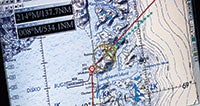
Although Maj. Falvo is in the left seat, for now it’s Captain Tim Novak, the navigator, who’s running the show. “Field elevation is 10,665 feet,” begins his brief on the Airborne Radar Approach to Camp Summit. “Minimum safe altitude within 25 nm is 11,900 feet. Minimum descent altitude is 10,980 feet. The camp will be to the left on landing.”
“The most important responsibility of the navigator is to get the aircraft in a safe position to land,” says First Lieutenant Kelly Williams. While Maj. Falvo continuously scans the instruments, Capt. Novak instructs directional changes based on an interpretation of the onboard radar scope. “There’s a precise ballet that goes on between the navigator and pilot,” describes Major John “Omar” Bradley. As the newest pilot in the unit, he’s flying his first trip to Greenland, but it doesn’t show: “The pilot is super-concentrated on airspeed and sink rate, not even looking outside. And the navigator is looking at the radar altimeter, so the job of the copilot is to visually acquire the skiway.”
“Pilot, I need a heading of 258,” Capt. Novak requests, giving corrections each mile. “I need a heading of 259.”
And then Maj. Elsworth spots the flags that mark the skiway: “Copilot has the approach. Pilot, you can transfer your attention to the windscreen.” Maj. Falvo raises his gaze from the panel, and although his trained eyes recognize the white-on-white skiway, all I still see is a lot of nothing. Pure white nothing.
 |
 |
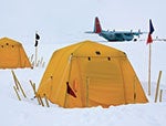
| The 109th supports the National Science Foundation at remote outposts such as Camp Summit (left), where researchers live in tents on an ice depth of more than 10,000 feet. “Nemo the Blimp” (right) is a tethered balloon that makes a vertical profile of the atmosphere, collecting temperature, humidity, wind speed and direction. | |
“Our mission requires teamwork and communication to flow smoothly,” says Maj. Falvo. “It’s great to see it all come together with the precision of a Swiss watch!like a well-oiled machine.” On downwind, landing gear is extended and massive skis are lowered below the wheels. Made of aluminum and steel, the main-gear skis are 20 feet long and 5 feet wide, and each weighs a ton; the nose ski is 10 by 5 feet.
“Camp Summit, Skier 71 left base Skiway 26,” radios Maj. Elsworth. I make out some dark specs below, like bugs on a windscreen. “300 feet,” calls out Novak, still glued to the radar altimeter, “100, 50, 40, 30, 20, 10.”
The 109th Airlift Wing
Based at Stratton Air National Guard Base in Scotia, N.Y., the 109th Airlift Wing supports the National Science Foundation (NSF) on polar airlift missions and is the only unit in the world that flies the ski-equipped LC-130. From April to August, the unit transports supplies and scientists to research outposts in Greenland. From October to February, the 109th flies resupply missions from NSF’s McMurdo Station in Antarctica to the South Pole and other remote locations. (Visit www.goang.com and www.nsf.gov.)
 |
“Although his trained eyes recognize the white-on-white skiway, all I still see is a lot of nothing. Pure white nothing.”
Members of the 109th team are passionate about polar aviation and love what they do. “The flying is unique and challenging, like it must be to land on a navy ship,” asserts Maj. Bradley. “My absolute favorite part of the 109th is the amazing people. I’m happy to go to work every day with them.” His coworkers are a mix of full- and part-timers with “regular” jobs and varied hobbies. My public affairs host, Lieutenant Colonel Robert Bullock, is president of the New York State Archives Partnership Trust, and his assistant, Captain Shane Gernand, is a project manager at General Electric.
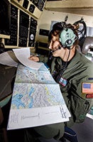 First Lt. Kelly Williams navigates from New York to Kangerlussuaq. |
“The LC-130 is like a giant floatplane,” says Lieutenant Colonel Mark Doll, a full-timer on a leave of absence from Northwest Airlines. “Not a high-power one like a Beaver, but more like a J-3 Cub. It requires finesse because you have barely enough power to get the airplane to fly.”
“It’s extremely versatile,” adds Lieutenant Colonel Mark Sakadolsky, who has been with the unit 22 years and flies up to 30 polar missions yearly. “We fly on snow, on paved runways and in the desert, and we perform air drops. The mission I do here is like being a bush pilot.”
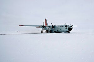 Overcast skies create challenging near-whiteout conditions. |
Camp Summit
Touching down on the 15,000-foot skiway is bumpy and noisy, but with propeller pitch set to reverse, it doesn’t take much distance to stop. “As a general rule of thumb,” Falvo tells me, “2,000 feet is enough distance to bring the aircraft from near takeoff speed down to taxi speed. As airspeed decreases, the friction between the skis and the snow increases, since any lift the wings were generating goes to zero, and the weight is transferred to the skis. It feels similar to flying a single-engine airplane on a soft field.”
I step out of the Hercules and enter a cold, surreal landscape whose endless whiteness is punctuated by bright-yellow tents, piles of cargo and scientists traversing their workspace on skis. The horizon remains elusive and there’s a quietness disturbed only by the crunch of ice underneath boots. During our time on the ground, the aircraft’s four engines remain running, to the tune of 2,800 pounds of fuel per hour. “If engines get too cool, the oil begins to thicken,” explains Maj. Bradley. “Every time you stop and start an engine, there’s another chance that something may not let the engine start again. If you can keep ’em running, keep ’em running.”
 |
The Summit research station, at 72 degrees north latitude and on an ice depth of more than 10,000 feet, supports 40 personnel from the NSF. The location attracts some of the foremost scientists in the world as well as first-time college students. Much of their work focuses on global climate change, using ice core samples to analyze weather system history. (Read “Ice Stories: Dispatches From Polar Scientists,” a blog maintained by these Arctic researchers, at icestories.exploratorium.edu.)
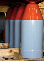 Rocket bottles are attached to the fuselage for additional takeoff power. |
“The Greenland ice cap is the only big ice cap in the northern hemisphere, so it’s very important,” explains ice coring expert J.P. Steffensen from the University of Copenhagen’s geophysics department. “Greenland is a living mountain made of one mineral: frozen water. Over time, the overall ice cap shape stays the same, but new snow is deposited in the middle, and ice on the edges breaks off.” Researchers have drilled through layers dating 125,000 years old; and a new project aims to go as deep as 250,000 years. “Something big is going to happen,” predicts Steffensen. “We’re in an interglacial period now. An ice age is a concern, not just global warming. Scientists provide facts to politicians who make the moral decisions.”
Getting our ski bird off the snow isn’t an easy task, and our first two takeoff “slides” are aborted. “Much of what we do is a matter of technique, not always procedure,” says Maj. Falvo. “Sixty-five knots is in the ballpark of when it’s possible to lift the nose and have enough elevator authority to keep it off the snow, but much of this depends on snow conditions, center of gravity, flap setting and fuel quantity, so it isn’t really an exact airspeed every time.” Pilots will try different flap settings, rearrange cargo or leave equipment on the ice. On open snow, a takeoff slide can extend as far as 20 miles! When necessary, the crew will employ assisted take-off (ATO—not JATO, which implies the use of a jet engine). Eight rocket bottles attached to the fuselage will provide the same power as an additional engine for just 15 seconds, so timing is critical.
 |
 |
 |
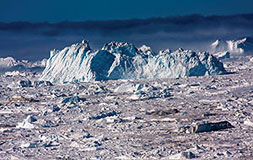
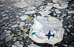
On our third takeoff attempt, the nose comes up and stays up. As we fly west from the center of the ice sheet toward its edge, the monotone terrain transforms into little ripples of snow and then sizable cracks, deep crevasses, ice upthrusts and, finally, gigantic glaciers with calving icebergs—we’re flying in fast-forward through geological history. Disko Bay greets us with a stunning sight of immense floating icebergs and pools of brilliant aqua and turquoise glacial water.
 |
 |
Camp Raven
Operating in such austere conditions requires specialized training. At Camp Raven, 6,930 feet MSL, pilots practice takeoff and landing skills on a groomed 6,251-foot skiway, as well as on the open snow. A physically demanding survival course, nicknamed “Kool School,” is held every two years at Raven, where winds can reach up to 100 mph. Participants are educated about survival gear and how to build shelter and generate drinking water.
Married couple Mark and Lou Albershardt make up the entire population of Raven, and aside from the abandoned DYE-2 radar site, their modest living quarter is the only structure for hundreds of miles. (Yes, they’re avid cross-country skiers.) They’re a vital part of operations, maintaining the skiway and transmitting weather observations to base ops.
 Greenland (a slightly misleading name given that its landscape is 80% ice) is home to 56,400 people and 29,000 Siberian husky sled dogs. Jakobshavns Fjord meets Disko Bay on the western coast in a stunning display of glaciers and floating icebergs. |
Kangerlussuaq
It’s 24 hours of daylight and mosquitoes are in full force in Kangerlussuaq, formerly Sondrestrom U.S. Air Force Base. Musk ox and reindeer roam the hillsides; howls of husky sled dogs permeate the tundra. At the head of a dramatic 105-mile fjord, this west coast town exists solely to support its airport and receives up to 50 flights daily during the summer: Air Greenland runs commercial flights from Copenhagen and within Greenland (no two towns are connected by road); mineral companies charter helicopters and transatlantic ferry flights stop for fuel. Base operations for the 109th at Kangerlussuaq include mission planning, maintenance and spare-parts storage.
“The 109th couldn’t do what they do without Polar Resources,” allows Lt. Col. Bullock. CH2M Hill Polar Resources (www.polar.ch2m.com) provides logistics planning of air support and other services for NSF camps. “It’s a balancing act with cargo and passengers,” explains Mark “Sparky” Begnaud, a polar logistician. “And the wild card is Mother Nature.” On one flight to the ice cap, 23 members of the Danish parliament join us, and Polar Resources doesn’t take this lightly. “There’s always a danger of getting stuck and if they have to stay, it will be disruptive to the research efforts.”
It’s 3 a.m. when we board Skier 93 for the return to New York, but the sunny sky reads more like 3 p.m. Loadmasters have packed the cargo bay with everything from coolers and mountain bikes to science equipment and a 10-foot broken prop—the web seating arrangement for passengers is tight. Up front, Lt. Col. Doll, ruminates about where we’ve been. “Our mission challenges us to navigate where there are few charts, to land where the conditions may not be fully known and to take off from snow conditions that vary hour by hour.” Six and a half hours after departing Greenland’s Arctic, we touch down in upstate New York to a warm June afternoon. Sweaters are shed, cell phones beep back to life, and the crew disperses to families, friends and their “regular” lives. “I tell people where I’ve gone, and they don’t believe me,” smiles 1st Lt. Williams. “It’s hard for them to fathom.”
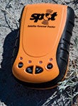
| Spot Satellite Personal Tracker www.findmespot.com |
|
Spot is a tracking device that uses GPS and satellite to allow users to communicate their latitude/longitude coordinates via e-mail and text messages by indicating a status of “OK” or “Help.” In a survival situation, the 911 button can be used to activate emergency rescue services. Provided the Spot device has a clear view of the sky, it should work anywhere that the Globalstar communications network covers. I took mine to the Greenland ice cap, and friends back home were able to follow my journey in real time on Spot’s tracking website, overlaid on a Google Earth map. [For a full review, see “Tech Talk: Spot Satellite Personal Tracker” from Plane & Pilot November 2008.] |
|

