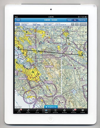
 iFlightPlanner’s app displays preplanned routes on sectional charts along with GPS-based aircraft position. |
For some time now, iFlightPlanner.com has offered a web-based service combining flight-planning and logging features with a mobile version that’s supported on many smartphones. Their new iPad app is very much a work in progress, as we’ll see.
The app is downloaded from Apple’s App store and installs on any iPad running iOS 4.3 or later. To use it, you’ll also need to sign up for a free account on iFlightPlanner.com. Planning flights is done as a four-step process through the website (which can be accessed from an iFP Online button in the iPad app, or on any computer with a web browser and internet connection).
The online flight planner requires a DUATS account, and supports typical options for airways, direct, VOR or custom routing (which can be done graphically by clicking the right mouse button to create a new waypoint that can be dragged wherever you want on a sectional or IFR en route chart). After that, you have the option to receive an FAA-certified weather briefing and file a VFR or IFR flight plan with the FAA. At this point, you’re required to click a check box absolving iFlightPlanner of any responsibility for whatever information you’ve entered, and then you can finish your flight entry.
With a flight entry completed, clicking a Sync Flights button in the iPad app adds the newly created flight to a list, and any flight on that list can be selected for an on-screen moving-map display. As with iFlightPlanner’s website, the iPad app displays the route on your choice of sectional, or IFR en-route (low or high) chart, which also shows TFRs and local weather for airports along the route. However, the iPad app offers no capability to edit the route.
If you have an iPad (with built-in GPS) or a compatible external GPS, the app will show your aircraft position, and four customizable data fields (set to groundspeed, altitude, heading and latitude/longitude by default).
Other options include course over ground and Zulu time. A navigation log also can be displayed showing altitude, route, winds, magnetic course/heading, true airspeed/groundspeed, fuel time and distance for each waypoint.
In addition to the moving-map and navigation log for preplanned routes, the app provides airport data based on the FAA Airport/Facilities Directory, including location, radio frequencies, pattern altitude, fuel availability, runway information and local weather conditions (when available), along with FAA airport diagrams and approach plates. All of these may be downloaded (by state or for the entire U.S.) for availability in flight.
The features listed so far are free. For an additional fee (starting at $9.95 per month) the website adds a customizable weight-and-balance calculator to the flight-planning process and an online logbook function that records flight hours and exports in a spreadsheet format. However, you can only access those features from the iPad if you have an internet connection, which isn’t generally available in-flight.
Andy Matthews, who co-founded iFlightPlanner.com, told us that a new premium version of the iPad app is planned for release later this year that will support offline flight-planning weather briefings and weight-and-balance calculations directly on the iPad, and will offer native-weather display rather than using the web-based interface. He also noted a unique feature of iFlightPlanner: You can designate latitude/longitude pairs as departure and arrival coordinates as an alternative to charted airports. That may be especially useful to helicopter and seaplane pilots.
To learn more about the iFlightPlanner for iPad, visit www.iflightplanner.com.


