 |
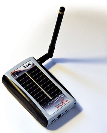
The iLevil SW from Levil Technology Corp. is the second device we’ve seen so far this year that combines a portable Autonomous Dependant Surveillance-Broadcast (ADS-B) weather/traffic receiver, wide area augmentation system (WAAS)-enhanced GPS, and attitude and heading reference system (AHARS) in a single box. It breaks new ground with two features we haven’t seen before—solar cells to help keep the battery charged, and a data port that accepts input from other devices, including Zaon’s XRX portable collision avoidance system (PCAS). That’s potentially important because it gets around the major limitation of portable ADS-B devices that only receive on the 978 MHz frequency—unless you or another airplane nearby has ADS-B out equipment, you won’t see any traffic.
Physically, the iLevil SW is a gray and black plastic box that’s a bit larger than a pack of king-sized cigarettes, at 2.6×4.3×1 inches. One side has an antenna, and on the back you’ll find a universal serial bus (USB) mini-port, on/off switch, charging light and a serial-in jack used when connecting it to other devices. The iLevil has an internal Li-Ion battery that the company rates at three to four hours, although on a bright day, the solar cells can extend that significantly—after a one- hour test flight on a sunny day, it still showed a 92% charge.
The iLevel SW supports applications on Apple’s iOS (iPhone and iPad), Android and even Windows-based devices. It communicates with iOS and Android devices through a built-in Wi-Fi network. I tested it with two iOS applications: WingX Pro 7 from Hilton Software and Austin Meyer’s Xavion.
WingX is an old friend—I first reviewed an early version (which ran on Windows-based Pocket PC hardware) some seven years ago. It has evolved into a complete electronic flight bag (EFB) app with preflight planning, moving map, electronic charts, a terrain profile view, ground proximity warning and airport information, including optional fuel pricing, among much more. As with most EFB apps, WingX requires a data subscription, and has many options for VFR and IFR pilots. Used with the iLevil, WingX also provides ADS-B weather, including NEXRAD radar images and field conditions, and traffic (with the limitations noted above). It also supports the iLevil’s built-in AHARS with an effective attitude indicator or a simple synthetic vision display. One particularly nice feature of WingX on the iPad is a split-screen option, so you can have the attitude indicator or synthetic vision on half the display, while using the other half for a moving map or electronic chart.
haven’t seen before.
Xavion, on the other hand, isn’t a conventional EFB app, although it does provide a moving map and will display ADS-B NEXRAD images. It’s the brainchild of Austin Meyer, an iconoclastic engineer who’s the brains behind the X-Plane flight simulator. Xavion applies flight simulator logic to solving a problem we all hope never to face in flight: What happens if the engine quits? If that happens, Xavion automatically selects the nearest runway you’re in a position to reach, and provides guidance to that runway using Highway in the Sky (HITS) fly-through boxes superimposed on a pretty impressive synthetic vision display. Xavion doesn’t require a data subscription—$99 buys the app and includes a world-wide database derived from X-Plane.
 |
I tried both WingX and Xavion with the iLevil on a one-hour test flight near my home base in Modesto, Calif. Both apps worked well. If you could only have one, WingX offers a much more complete feature set. I found the attitude indicator in WingX both accurate and easy to use.
Xavion has no preflight planning functions, and while it includes a worldwide database, it doesn’t provide electronic aviation charts—but automatic guidance to the nearest runway is a very impressive feature. I tested this on a simulated engine-out near New Jerusalem, an unattended runway, and flying through the HITS boxes got me on short final with no problems. It’s a very impressive app.
Neither app displayed traffic during my test flight, which isn’t a surprise, since my airplane isn’t equipped to transmit 978 Mhz ADS-B out signals, and thus doesn’t cause ground stations to relay traffic detected by RADAR or using the 1090 Mhz Mode-S frequency that’s common on heavy aircraft. I don’t consider the iLevil, or any other portable ADS-B device, to be an acceptable traffic solution. The ability of the iLevel to accept input from other devices, such as Zaon’s PCAS XRX, might offer a way to get close-range traffic, but that would increase the already hefty price for this solution.
 |
Since weather was clear during my test, I was unable to see NEXRAD imagery. I was able to display local field conditions on WingX, and there are screen- shots on both the Hilton Software and Xavion web sites that illustrate how the apps display ADS-B weather radar.
I have one gripe about the iLevil hardware: No mounting is supplied. I taped mine to the glare shield on a Skylane, and that was sufficient for a test flight, but I’d suggest at least a Velcro strip, which Levil ought to include in the box.
In addition to the iLevil SW, the company makes a more advanced version aimed at the experimental market. The iLevil AW lacks the solar cells, but adds a remote GPS antenna and internal pressure sensors suitable for use with pitot and static sources. In effect, used with appropriate software, it enables a completely portable digital primary flight display (PFD).
For more information on the $1,195 iLevil SW and $1,395 iLevil AW, browse www.aviation.levil.com/iLevil.htm. Both WingX and Xavion are available on the iPad app store.


