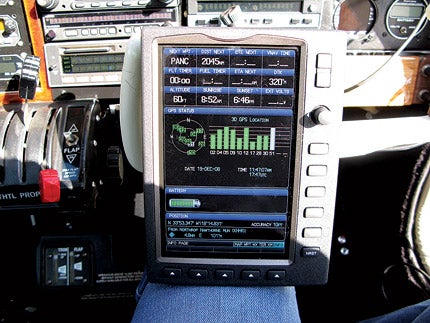
 MODERNâTECHNOLOGY. GPS units such as the Garmin G96 make dead reckoning a distant memory. |
For better or worse, I learned to fly in the days when there were still A-N ranges up and running, not many, but a few. NDB approaches were everywhere, VORs were about as good as it got, and DME was considered pretty exotic stuff.
My first airplane, a Globe Swift GC-1B, had a Narco VHT-3 Superhomer, an antediluvian, tube-style, crystal-controlled com with 12 channels that could occasionally transmit a signal across the ramp. I carried another dozen crystals for additional frequencies in those days and could remove crystals I didn’t need and substitute appropriate ones. The com could also serve as a basic VOR nav receiver.
My Swift also boasted a Bendix T12D ADF that worked on alternate Thursdays when the moon was full. Actually, the T12D was probably a good, basic unit—mine was just old and tired.
Automatic direction finding was the simplest and most complex form of radio navigation. It was simple: All you had to remember was the needle always points directly at the station (okay, not always). Navigating by ADF was almost idiotproof inbound to the station. The bad news was that low-frequency signals are susceptible to many forms of static interference, and navigating away from the station was problematical.
Today, ADF is out of style. That’s okay in a world of copious VORs and reliable GPS signals, but it can be more than a little scary in the mid-Pacific when GPS blinks and you’re still 1,000 miles from a small island with an NDB, and you have no ADF on the panel of a new airplane and no positive way to find land.
In the not-so-good-ole days, the prevailing navigation method for general aviation was most often point and shoot. General aviation’s alleged fat cats rarely were; and aircraft owners often couldn’t afford exotic VHF/LF avionics. Dead reckoning and pilotage more often were the rule. You simply plotted a course and flew by reference to time-speed-distance, or you pointed the nose at the nearest landmark you could see, then picked another visual cue in the same direction and continued the process until you found your destination.
It was pretty simple stuff. When the radios weren’t obliging, DR/pilotage worked most of the time, and it even directed Lindbergh to Paris 83 years ago. It even routed me to Shannon, Ireland, from Gander, Newfoundland, Canada, 33 years ago on my first ferry flight.
I made that trip flying with Phil Waldman, managing director of Globe Aero in Lakeland, Fla.—at the time, the world’s largest general aviation ferry company. I was doing a story on how Piper delivers airplanes around the world, and since my business airplane in those days was a two-year-old Seneca II, Waldman agreed to let me fly the new Seneca to Paris for static display at the 1977 Paris Air Show. Waldman rode shotgun in the right seat.
According to Jeppesen, the Great Circle distance from Gander to Shannon is 1,717 nm, and there’s not even a rock sticking up on the way across. There are 46 degrees of longitude separating Gander from Shannon, and the weather briefer at Gander provided wind charts with his best guess on winds aloft for the entire crossing. The regulations required that I report my position on HF to Gander or Shannon about every five degrees or nine times between Canada and Ireland.
I ran the nine wind triangles through my E6B several times to make certain I had the numbers right. We departed Gander, and I headed out across the Atlantic, convinced there wasn’t a snowball’s chance in hell that Shannon would be waiting for me on the other side.
Waldman was casual and relaxed. With something like 200 international crossings in his logbook, he watched in amusement as I rechecked my calculations, even while we were en route.
Of course, I had no way of knowing if I was anywhere near the positions I reported—I was simply trusting the wind forecast to be accurate. About every hour and a half, I’d report to the controller where I hoped I was, with little confidence that I was actually there. I’d reposition the DG-bug by a few degrees with every new position and hope for the best.
One wave looked like the next as we droned along in our aluminum cocoon. The Seneca’s cockpit is actually friendly and comfortable, but it feels like an MRI machine when you’re trapped for 11 hours, suspended in sky stacked 11,000 feet above one of the world’s angriest oceans. On that first trip, I learned the most important lesson of ferry flying—it’s a lot like being in jail, except there’s a greater chance of drowning.
There were no longer any convenient weather ships holding position at known locations in mid-Atlantic and operating low-frequency beacons to help steer airplanes across the pond.
When I was finally handed off to Shannon Radar at what should have been 175 miles west of Shannon, the Irish controller came back and reported, “Radar contact at 177 miles, three miles south of flight plan.”
I couldn’t believe it. All I’d been doing for the previous 10 hours was rotating the bug to the new heading every 80 minutes and letting the autopilot hold me on course. It seemed inconceivable that dead reckoning had actually WORKED.
The other day, as I was monitoring the readout of the Garmin 696 in my Mooney, I had to reflect on how far we’ve come. I’ve been fortunate to use a variety of GPS units from Magellan, Trimble and Garmin over the last 20 years, and I’ve been constantly amazed at their capabilities. Who would have guessed in the mid-’60s that we’d someday have a universe of satellites orbiting overhead that could pinpoint our position in three dimensions to an accuracy of a few feet at refresh rates of five times a second?
At its core, that’s all any GPS receiver does, derive a position. Despite the complexity necessary to generate position resolutions, GPS is an incredibly simple method of determining position. All other functions are mere applications of long-standing computer technology.
Today, GPS is accepted as the standard method of navigation for the military, general aviation and even many of the airlines. Inertial nav was once the airlines’ dominant form of maintaining a course for long-range navigation, but GPS is rapidly displacing inertial from the cockpits of airliners worldwide.
The Garmin 696 is unusual in that it’s the largest and most expensive portable GPS on the market, but perhaps appropriately, it’s also the most talented, and it’s almost silly-simple to use. The model was introduced two years ago at Oshkosh, and despite a list price of $2,995, the system continues to sell remarkably well.
Aircraft navigation has realized amazing improvements in the short span of a single century, from dead reckoning and pilotage in the first 50 years of powered flight, to ADF/VOR in the next 30 years and now to GPS in the last 20 years.
GPS is, by far, the most accurate and intelligent navigation system ever offered for general aviation consumption.
But dead reckoning was more fun.


