 |
Lately, several new acronyms have entered the GPS field; most notable among them is WAAS, which stands for Wide Area Augmentation System. To VFR pilots, WAAS is just a new level of GPS that’s more accurate and reliable, but to IFR pilots, it brings a confusing array of new options. Look at one of the new RNAV (GPS) approach plates, and you’ll see unfamiliar terms, especially in the minimums: LPV, LNAV and LNAV/VNAV. It’s enough to leave a pilot scratching his or her head, but in the next few pages, I’ll try to make sense of it for you.
All GPS navigators (with or without WAAS) use signals from an artificial constellation of 24 NAVSTAR satellites. The satellites each carry an ultra-accurate, cesium-based atomic clock, and broadcast a timing signal at precise intervals. The GPS navigator picks up signals from three or more satellites (more is better), compares the timing signals and then determines its location on the surface of the earth with accuracy in the tens of meters. With a signal from a fourth satellite, it can calculate altitude.
For IFR use, pre-WAAS navigators include a barometric input used as a check on the calculated altitude and additional logic (Receiver Autonomous Integrity Monitoring, or RAIM) that compares the calculated position by using all satellites in view. RAIM constantly checks to see if the calculated position and altitude from all satellites agrees within a preset limit. If not, a flag is dropped indicating to the pilot that the GPS position can’t be trusted—which is why pilots filing IFR with pre-WAAS GPS navigators are required to file a non-GPS alternate.
Some pre-WAAS GPS navigators can use the barometric input to provide advisory vertical guidance, but there are always errors in barometric altitude (and there could be additional errors in the computed GPS altitude), so instrument approaches with this equipment are limited to nonprecision minimums: typically no better than one mile from the end of a runway and 500 feet above the ground. And you must be prepared to break off the approach at any time if RAIM decides the computed position is unreliable.
WAAS uses three additional satellites in geostationary orbit some 22,000 miles above the earth’s surface—at that altitude they take 24 hours to orbit and don’t appear to move in the sky. WAAS transponders on the satellites broadcast signals that tell a WAAS-equipped navigator which of the regular GPS satellites can be believed and which should be ignored; they also add differential corrections to the GPS signal based on information from ground stations. The result is supposed to be so reliable that the FAA doesn’t require any other kind of navigation equipment to file IFR, and it increases accuracy to a few feet in both horizontal and vertical directions, without any requirement for a separate barometric input. Navigators built this way meet Technical Standard Order (TSO)-C146a; at this writing, only two are in use: the GNS-480 (formerly Apollo CX-80) and GNS-430W/530W, both from Garmin.
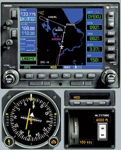 Garmin’s recent upgrade to its popular GNS-430/530 navigators offers WAAS capability with vertical guidance. |
Flight Planning For WAAS
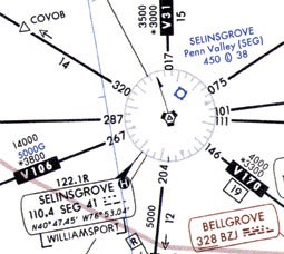
For VFR pilots, WAAS offers a reliable backup to conventional navigation methods. Yes, you can put in your departure and destination and let the GPS give you a straight-line course between them, but unless it’s over ground you’re familiar with, you’d be wise to spend a little time with sectional charts. IFR pilots need to break out en route charts (or electronic flight-planning software) and figure out which airways to use; this is the first place where WAAS can pay off in a big way—with lower MEAs on some airways. In one example, WAAS-equipped pilots can expect to fly at 5,000 feet instead of 14,000 feet.
With the route worked out to your destination, it’s time to look at the approach plates and get a preflight briefing that includes a check of NOTAMs. In the unlikely event of a systemwide WAAS failure, an areawide NOTAM will be issued. It’s much more likely that you’ll see site-specific NOTAMs: “!GPS IS UNRELIABLE AND MAY BE UNAVAILABLE!” or “!WAAS LNAV/VNAV AND LPV MNM UNREL!” In the first case, you can’t count on using GPS in the specified area or for the specified time. If this affects you, you’ll need to use some other form of navigation or change your route. If you’re planning an instrument flight and your destination is in the affected area, you’ll need to plan for a non-GPS approach. The second case affects which minimums instrument pilots can use for an approach.
There’s one more preflight step you may need to take, depending on your equipment. Garmin supplies satellite-coverage prediction software that’s built into the GNS-430/530W trainer and is available separately for the GNS-480. It requires an Internet connection and analyzes satellite coverage over your planned flight path. It then advises you of any issues that could affect your use of a navigator as a primary form of navigation along that route. It’s required for any flight taking place more than 200 miles from your home airport. This means that on multiday trips you’ll need to carry a laptop computer (or electronic flight bag) with the prediction software loaded, and find a place where you can connect to the Internet before launching for the day.
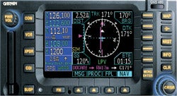 On instrument approaches, Garmin’s GNS-480 (the first WAAS navigator certificated to TSO-C146a) can provide ILS-like vertical and horizontal guidance. |
Planning A WAAS Approach
Any approach-approved GPS navigator, with or without WAAS, can fly to nonprecision straight-in lateral navigation (LNAV) or circling minimums—typically getting you down to 500 feet above the runway and requiring a mile or more visibility. If you have an approach-approved navigator with WAAS or a barometric input, you may be able to use slightly lower lateral navigation with vertical guidance (LNAV/VNAV) minimums. This looks like an ILS localizer and glideslope presentation, but may be less accurate (or have a smaller protected area at the airport you’re approaching) and thus requires higher minimums—on the order of 400 or 500 feet and one mile. The most desirable approach, with the lowest minimums is localizer precision with vertical guidance (LPV), which can be as low as a category-1 ILS: 200 feet and half a mile, though 250 feet and one mile are currently more common.
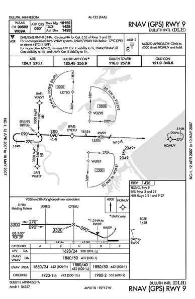
In most cases, a local NOTAM will warn you if satellite coverage (or other issues) preclude certain approach minimums. However, some airports with WAAS approaches aren’t included in the NOTAM reporting service. On FAA National Chart Office (NACO) plates, this is indicated by a white “W” on a black background in the briefing strip just below the WAAS channel number box. Jeppesen’s presentation is a bit different but provides the same information. In these cases, you’re required to plan for nonprecision LNAV or circling minimums, though lower minimums may be available when you arrive.
 |
With the preflight briefing complete and a flight plan on file, it’s time to check whether the GPS navigator’s database is up to date—it will tell you during the power-up sequence. Assuming the database is okay, you can now enter your flight plan. The exact steps vary from unit to unit, but generally you’ll define the departure and arrival airports and waypoints between them. If you’re flying IFR, you’ll have the option to select departure and arrival procedures (it might be wise to call clearance delivery first—they don’t always give you what you ask for). Once that’s done, it’s time to call ground control for taxi clearance and complete your run-up checks. Then you can launch.
En route, the GPS (with or without WAAS), gives you navigation signals similar to those from a VOR. Deviation off course is shown on the HSI or CDI—though with GPS navigation, deviation is displayed linearly (with full-scale deflection indicating five miles off course) rather than in angle. You can also monitor your flight on the navigator’s moving-map display (or on an MFD if you have one).
For IFR pilots, the big difference between TSO-129a (pre-WAAS) and TSO-C146a (WAAS) navigation only shows up on area navigation (RNAV) approaches. For example, look at the approach plate for the RNAV (GPS) Runway 9 approach to Duluth International Airport on page 66. The WAAS channel number is shown in the upper left corner. The plan view shows a “T-Bone” layout typical of RNAV (GPS) approaches, with two initial approach fixes (IAFs) on either side of a long straight-in final approach course. If ATC clears you for the approach without specifying a fix, you’re expected to navigate directly to whichever IAF is closest to your route and then make a turn direct to the initial fix (IF). From there, you’ll turn to the final-approach course, and from the final-approach fix (FAF), you’ll descend to whichever set of minimums you’re using.
Flying A WAAS Approach
Once the approach is activated, the navigator displays “TERM” to indicate terminal mode, either on the built-in display or on a separate annunciator (which may be required if the navigator’s built-in display is located too far outside the pilot’s normal field of vision), and guides you to the selected IAF. In “Vectors-to-Final” mode, it indicates deviation from the extended centerline. As you approach an IAF, the navigator prompts you that a turn is coming up. IAFs are fly-past waypoints; you’re not expected to fly over them, but to begin a standard-rate turn to the new course as you approach one. The navigator provides guidance through the turn. As you approach the FAF (when pre-WAAS navigators show APR to denote approach mode), the annunciation will change from TERM to LPV, LNAV/VNAV, LNAV+V or LNAV to indicate what minimums you’re authorized to use. You’ll note from the approach plate above that LPV minimums as low as 200 feet above the runway and with ½ mile visibility are possible at Duluth—but whether you can fly them depends on conditions at the airport and in the satellite constellation. When I simulated this approach at home (using Garmin’s GNS-530W trainer, which can be downloaded from a link at the end of this article), only LNAV+V (lateral navigation with advisory vertical guidance) minimums were available. If I had been flying this approach for real, that issue should have turned up in the preflight planning, either with a NOTAM or when I ran Garmin’s satellite-coverage prediction software.
As a practical matter, flying to LPV, LNAV/VNAV and LNAV+V minimums are all basically the same: You get both lateral and vertical guidance on your HSI or CDI. If you’re flying at the minimum authorized altitude for the segment from the initial fix to the FAF, you’ll intercept the computed glidepath at the FAF, and then follow it down an ILS-like glideslope (three degrees at Duluth) to the touchdown zone. For LPV and LNAV/VNAV approaches, the missed approach point is the decision altitude (DA), just as with an ILS—so you’re expected to follow the glidepath. For LNAV+V, you have the option to descend to the MDA any time after the FAF, as you would in a nonprecision LNAV or circling approach. In any case, the end of the runway is a flyover waypoint, and if you’re not in a position to make a landing by then, you’ll have to execute a missed approach. The navigator becomes a big help at that point, because once you tell it you’ve missed (by pressing the OBS button on a GNS-430/530, for example) it provides guidance through the missed-approach procedure, including any holding-pattern entry that may be required.
The Significance Of WAAS
When I last wrote about WAAS for Pilot Journal in 2003, only seven airports had approaches with LPV minimums. Today there are some 710 airports with LPV minimums, and the FAA is on target to add 300 more every year. Back then, there was only one TSO-C146a navigator. Today there are just two, but more are on the way. A representative of the FAA’s WAAS program office told me in an interview that Avidyne is working to offer WAAS-based vertical guidance on their Entegra glass flight decks, and that Garmin “is cranking out something like 500 GNS-430/530 upgrade receivers each week.” Back in 2003, the airlines were ignoring WAAS and lobbying the FAA to put money into a Local Area Augmentation System (LAAS) that would offer Cat-II/III capability. Recently, the FAA downgraded LAAS to a research and development program with no plans for operational deployment (though FedEx is working—at their own expense—with the FAA on an LAAS test bed at their Memphis hub). And an FAA source told me that one major cargo carrier will announce acquisition of some 250 GPS-WAAS navigators soon—perhaps by the time you read this. It looks like WAAS is here to stay!
 |
Like any new technology, WAAS has its problems. Last fall, bench tests indicated that the GNS-480 (and other Garmin WAAS systems, which all share a common architecture) might malfunction in “high noise and minimum signal conditions,” though so far there have been no reports of this happening in flight. As a result, FAA Special Airworthiness Information Bulletin CE-07-02 and Garmin Service bulletin 0621B limit use of this equipment to IFR flight (requiring a back-up non-GPS navigation method, a non-GPS alternate and Garmin’s prediction software). The same issue is delaying introduction of an LPV-capable derivative of the G1000 glass panel for new Cessna Mustangs. Garmin says that the problem will be fixed, but hasn’t said when. A representative pointed out that most Garmin GPS navigators have a built-in VOR receiver, and says that so far this hasn’t caused a major problem for customers.
One final thought: WAAS-enabled portables are both more accurate and more reliable than a TSO-C129a panel-mount navigator using conventional GPS with RAIM and a barometric input. Indeed, some portables—including Garmin’s Model 396 and 496, and C-Map’s AVmap EKP-IV (among others) include instrument approach waypoints in their databases. The software in those units isn’t designed to walk you through an RNAV (GPS) approach, and certainly won’t set you up neatly for ILS-like LPV minimums, but still could be a real lifesaver in a pinch!
For More Information:
GPS/WAAS Approaches
http://gps.faa.gov/CapHill/indexApproach.htm
(includes FAQs and an up-to-date list with LPV and LNAV/VNAV minima)
SatNav News
http://gps.faa.gov/Library/indexSatnav.htm
(from the FAA’s Satellite Navigation Project Teams)
Garmin GNS-480 and GNS-430W/530W Simulator/Trainer Software
www8.garmin.com/include/SimulatorPopup.html


