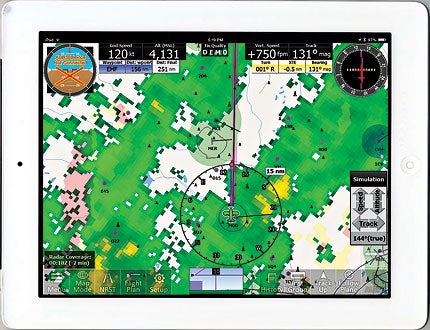
Adventure Pilot iFly GPS For iPad And Android
Full-featured GPS moving map and an electronic flight bag app for tablets
 iFly GPS can display weather from the Internet or ADS-B (with a compatible receiver). |
Four years ago, Adventure Pilot launched the first in their iFly series of handheld moving-map GPS devices. Since then, they've steadily improved the feature set, but found themselves competing against apps offering similar capability on off-the-shelf tablets. Last December, they responded by offering an app that basically provides the complete iFly feature set on an iPad. Version 8.1, which I tested on an iPad 2, expands the feature set and supports Android-based tablets, as well.
Installation is extremely simple---download the app from Apple's iPad App Store, and on start-up, you'll be prompted to select VFR or IFR and which states you want to cover. I selected California and Nevada, which required 417 MB. The entire U.S., including Alaska and Hawaii, would have required 8.1 GB. You'll want to be on a Wi-Fi connection as downloading that data can take quite awhile otherwise.
Once the data is downloaded, the app will start in its default map mode, which is capable of displaying digitized sectional terminal area and world area charts, plus a proprietary vector chart format and a vector-based weather mode (when connected to the Internet or a compatible ADS-B receiver). IFR users can also display instrument procedures, airport diagrams and low-altitude en route charts. Adventure Pilot uses a proprietary process to enhance digitized charts, which increases their contrast and uses color to highlight special-use airspace. All charts are georeferenced, so you can expect to see GPS-based aircraft position displayed properly.
Across the bottom of the map are a series of buttons. Tap "Flight Plan," and a simple form pops up in which you can enter a departure, destination and optional waypoints ("rubber-band routing" is also supported from the map view). A "Set Altitude" button displays a profile view showing terrain and special-use airspace along the route. Altitude selection is done using "Raise" and "Lower" buttons that are intelligent---single taps give you 50-foot changes, while holding down the buttons give you larger changes. The "Airspaces" button previews any special-use airspace along your route.
Most handheld GPS moving-map devices offer a simulator mode, so you can preview a route or experiment with features while safely on the ground. I've missed that on other iPad moving-map apps, but iFly has it---hidden under the Menu g About buttons. Once simulator mode is started, a set of buttons lets you increase or decrease altitude, airspeed and heading. I found this extremely useful while writing this review as the local weather (including embedded thunderstorms) wasn't suitable for flight-testing.
An "Instrument Group" button allows you to customize the display with simulated instruments, including a horizontal situation indicator that shows how far you're off the desired track, and---if a compatible attitude source is available---an attitude indicator. You can also switch from map mode to a simulated instrument panel that shows GPS-based ground speed, altitude, vertical speed and turn indicator; this could be a life-saving backup for instrument pilots in case of a combined electrical and pitot-static failure.
The "NRST" button brings up a list of airports near your current position, which is one of several ways to display iFly's built-in Airport/Facilities Directory (A/FD) data. It goes beyond what the FAA publishes in paper A/FDs with a feature called Real View that shows enhanced satellite imagery of the runways.
 iFly GPS enhances sectional (and other) charts to increase contrast and highlight hazardous terrain. |
What's missing? As someone who periodically flies to Mexico, I was disappointed to see that coverage for Baja California isn't included---it's covered by paper WAC charts. Adventure Pilot's website includes downloadable manuals (in PDF format) for their handheld GPS hardware, but not for the app. While I found the iFly GPS generally intuitive, a downloadable reference that can be searched and studied without a live Internet connection can be extremely useful to pilots. A company representative told me that both an updated manual covering the app and online videos showing how features work should be available soon. The app also lacks high-altitude IFR en route charts, which are essential for turbine pilots, and while its flight planning capabilities are impressive, iFly doesn't provide a method to get a full FAA weather briefing or file a flight plan.
That said, my experience with iFly GPS was generally quite positive. I've been impressed by Adventure Pilot's handheld GPS moving-map hardware, and I'm glad to see the same capability made available to iPad and Android tablet users. I hope the people at Adventure Pilot will continue to add features and improve the app.
A 30-day free trial is available when you download iFly GPS (from Apple's iPad App Store or Google Play, respectively for the iPad and Android versions). After that, a data subscription is required---$69.99 per year for VFR only or $109.99 per year for IFR/VFR coverage. Pilots who own more than one device can pay an extra $19.99 per year for a subscription covering up to three. The app is compatible with a wide range of external hardware, including GPS and ADS-B receivers and attitude/heading sources. Browse www.ifly.adventurepilot.com for more information.

Subscribe to Our Newsletter
Get the latest Plane & Pilot Magazine stories delivered directly to your inbox


