 |
Since 1930, the standard paper navigation chart for VFR pilots has been the venerable sectional, originally produced by the Coast and Geodetic Survey, whose aviation department has since become the FAA's National Aeronautical Chart Office (NACO). NACO sectional charts are widely available, and provide key data on terrain, airspace, navigational aids, etc. We all learn to use them in primary flight training. And they're in a format that has been proven over time. But we're now in the 21st century. Vast databases exist that provide the same information that's presented on sectional charts. In a sense, a paper chart is nothing more than a printed download from those databases. Is the sectional the best way for that data to be presented?
At 2008 EAA AirVenture, Jeppesen, which has competed successfully with NACO (and its predecessors) IFR charts for many years, announced a new line of VFR+GPS charts intended to compete with sectionals. Today, improved versions of Jeppesen's VFR+GPS charts cover the continental United States---providing the first alternative to the sectional chart since the 1930s.
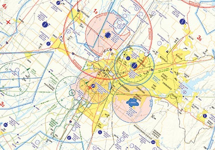
At first glance, a Jeppesen VFR+GPS chart looks a lot like a sectional. The cover shows the coverage area of the chart and gives the expiration date. But if you look closely at the coverage area, you'll see a huge difference: Sectionals always cover a set range of latitude and longitude, in a horizontal format oriented east and west. This isn't true of Jeppesen VFR+GPS charts. The W-1 chart, for instance, basically follows the west coast of California, from just north of San Luis Obispo to just south of Eureka, covering the San Francisco Bay Area and much of California's Central Valley, including Sacramento. This orientation was determined by traffic analysis---Jeppesen found that the vast majority of flights in the area were generally along the coast or through the valley, which parallels the coastline. I can confirm that from personal experience: My home base is Modesto (KMOD), and I've logged far more cross-country time in the valley than east over the Sierra Nevada mountains.
The second big difference between Jeppesen VFR+GPS charts and NACO sectional charts becomes apparent when you turn the chart over. Sectionals are two-sided, as every pilot who trains at Modesto knows all too well---at least one cross-country runs north to Sacramento, and we're all forced to learn how to draw a straight line that begins on one side of the chart and ends on the other. On the Jepp W-1 chart, by contrast, the map covers only one side. The other side offers supporting information, including a graphical depiction of airspace classes, ATC frequencies, latitude and longitude of VFR checkpoints (useful to anyone flying with a GPS that lacks an aviation database), special-use airspace information, and airport diagrams for some of the busier airports in the airspace covered by the chart, along with hotel, car rental and restaurant information at those airports. In effect, Jeppesen's VFR+GPS charts provide much of the information you'd get from both a NACO sectional and an airport guide.
There's a rather large catch to this that shows up in the W-1 chart: Jepp doesn't duplicate the airport data if the regular VFR+GPS chart overlaps an area chart. Jeppesen Area Charts are similar to NACO Terminal Area Charts, offering a higher resolution (1:250,000) and covering a smaller area. Its San Francisco Area Chart covers the entire San Francisco Bay Area and Sacramento, so the airport diagrams on the W-1 chart don't include any of those. Similarly, the GL-3 chart introduced at AirVenture doesn't cover Milwaukee or Chicago airports included in the Chicago Area Chart.
Jepp's aeronautical chart presentation also is different from NACO's. In most cases, the same information is available, but Jepp's color and style favors airspace and navigation data over terrain, and shows VORs and other navaids using Jepp's symbols, which are slightly different than NACO's. Both the W-1 and GL-3 charts notably are lighter than equivalent sectionals. Jepp's airspace presentation is particularly nice, clearly delineating the airspace class and altitude range---you can tell at a glance where the boundary between Class B and C or D airspace is, which can sometimes be difficult on a sectional. Airways, intersections and VFR checkpoints are easier to see on the Jepp chart, which also offers a unique feature: VFR grid altitudes, depicted as large red numerals, which provide terrain and obstacle clearance (1,000 feet for altitudes below 5,000 MSL, 2,000 feet at higher altitudes) for every 30 minutes of latitude and longitude.
The only things I could not find on Jepp's VFR+GPS charts were approach frequencies for Class C airspace. That information is available in a table on the back of the chart, but you should not have to turn the chart over to find it. Jeppesen Product Manager David McLean told me he has heard that comment from other users, and plans to add approach frequencies for all controlled airspace in future chart revisions. He also plans on adding subtle color changes to make the charts easier to use at night (Class B airspace on the current charts is shown in a bright orange-red, which can wash out if you use a red flashlight), and hours of operation for part-time control towers. He hopes to expand coverage beyond the continental United States, potentially to include Alaska, the Hawaiian Islands, Canada and Mexico---depending on demand.
Jeppesen VFR+GPS charts are currently available only through Jeppesen's JeppDirect service, though McLean told me the company is working to make the charts available through selected pilot shops and other dealers. En route charts (the ones equivalent to NACO sectionals) cost $11.99. Area charts (equivalent to NACO terminal area charts) cost $7.99. All VFR+GPS charts are updated every six months. For more information, browse jeppdirect.jeppesen.com and select VFR Paper Charts from the Charts, Navigation and Flight Planning Menu or call (866) 498-0213.

Subscribe to Our Newsletter
Get the latest Plane & Pilot Magazine stories delivered directly to your inbox


