
 |
Just as East Coast pilots count the Bahamas as something of an ultimate getaway, Left Coast aviators consider Alaska to be the destination of choice.
There are obviously major differences between the two in that the Bahamas are blessed with warm, benign weather (most of the time), and Alaska's meteorology can be considerably more challenging, but both are beautiful destinations, with different attractions.
Another major difference is that the Bahamas lie as little as 60 miles off the Florida mainland, while Central Alaska is more like 1,000 miles north of the Lower 48 states. The first few times I flew to or from Alaska, delivering a variety of airplanes up or back, I did so by the Alaska Highway route through the Yukon. I had heard horror stories about torrential rain and fierce icing along the coast, and I wasn't about to test myself against those risks.
Then, back in the early 1990s, I was hired to deliver a turbocharged/intercooled Mooney 252 from Anchorage to Arlington, Texas. Despite the airplane's impressive speed and economy, the owner had decided a high-performance retractable wasn't ideally suited to travel in the far north.
If the Mooney's excellent efficiency made it relatively easy to get around America's largest state, the gear system had expensive, aluminum gear doors, both of which the owner had bent during the first month of operation into semi-bush strips. Removing the doors entirely wasn't a reasonable option, so the owner decided to trade the Mooney for a Turbo Skylane.
My trip south was scheduled for late May, mid-Spring in Alaska, and when I arrived in Anchorage, the highway route was plagued with late winter storms and ice. While inflight icing along the coast can be a problem year round, it's often most significant in the Inside Passage where storms build to 20,000 feet or higher. I discussed the route with the briefer at Anchorage International, and he confirmed what I had been told by a number of other Alaskan pilots. Overcast and rain were common problems along the Southeastern Alaska route, though visibility usually remained flyable, and ceilings were most often 1,500 feet or higher.
Nevertheless, I decided to fly that trip from Anchorage to Ketchikan at FL220, far above any weather and relatively immune from icing.
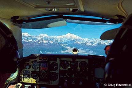
For a change, the trip went exactly as planned, something that had almost never happened before and hasn't since. I leveled at 22,000 feet and drifted across an air mattress of clouds with only the knife-like peak of 18,000-foot Mount Saint Elias sticking out the tops, suggesting what was waiting below.
The winds were willing, and the Mooney clipped along at a happy 220 knots. Ketchikan was clear when I arrived, and I was grateful not to have to shoot the ILS approach into the airport, as the runway is conveniently carved out of the side of a mountain. If you miss the approach to PKTN, don't do it to the right, as that's where the mountain hides.
My next trip involving the 49th state was a year later, and again, the weather along the Alaska Highway route was marginal, at best. The airplane was a Comanche 260 in excellent condition with tip tanks!and a run-out engine. The owner had contracted for one of Victor Sloan's remarkable balanced and blueprinted Black Edition engines from Victor Aviation in Palo Alto, Calif. Victor hired me for the pickup and delivery.
This time, I elected to try the low-level route from Anchorage through Southeastern Alaska to Bellingham. I had heard stories about pilots who flew around Southeastern Alaska below 2,000 feet for most of the rainy season, which often seems to last for most of the year. The weather was rarely good in Southeastern Alaska, but it was also rarely what most pilots would call bad, broken-to-overcast clouds with visibilities of five to 10 miles underneath and ceilings rarely lower than 1,500-2,000 feet.
The major concern was icing, a near-constant problem in the clouds of Southeastern Alaska. The obvious solution was/is to stay out of the clouds.
If you remained over the water for most of the trip, or even if you ducked inside the coastal islands, you could usually get where you were going without incident. The advent of GPS had made navigation almost silly simple, so finding the airports scattered around the islands wasn't a problem.
The Comanche was one of those beautiful, classic airplanes that the owner had restored and maintained meticulously, and despite the high engine time, I quickly became comfortable with the 260 hp Lycoming, characteristically smooth as an electric motor.
The owner had a full water and land survival kit in the baggage compartment, complete with a tent, 12-gauge shotgun, raft, vests, emergency medical supplies, water and rations, all reassuring hedges against the unexpected. I had lived and flown in Alaska for five years during my college days, and the survival gear was a comfort in case of the unthinkable.
I departed PANC, followed the highway southeast out of Anchorage down the Turnagain Arm of the Cook Inlet, jumped across the short section of land to cross the beach at Seward and was immediately overwhelmed by the spectacular beauty of Prince William Sound. I cut back inland slightly to approach Valdez, then turned out over the water.
After passing Valdez far to my left, I followed the GPS toward Yakutat, right on the coast and just north of the portal to the Inside Passage. As I might have expected, there was some floatplane traffic around Valdez and Yakutat, but not enough to worry about.
Passing Yakutat, I spotted a larger airplane coming the other way. I was surprised when a twin turboprop Bandeirante gave me a wing wag as he zipped by a mile to my left. I had expected to see other piston airplanes flying the low-level route beneath the clouds, but it was apparent that turboprops don't like ice either. (The following day, I took off from Ketchikan behind a Grand Caravan, and we played tag flying above Canadian waters all the way to Bellingham.)
Mount Fairweather and Glacier Bay drifted by to my left, and I continued southeast beneath the overcast, heading for a pit stop at Sitka on Baranof Island. Sitka is located in a small bay a few miles inland from the Pacific, so while it's not immune from fog and low visibility, it doesn't happen often. If Sitka socked in and you decided to alter course, you could fly back out over the ocean and continue along the coast.
After departing Sitka, I hopped over the small hills to the fjord-like ribbon of calm water protected by Baranof Island and continued to fly southeast toward Ketchikan, designated PAKT. The weather remained pretty much as advertised, and occasional splashes of sun lit up the low hills on both sides of the water highway.
Ketchikan was a welcome sight in the sometime sunshine. I landed, put in my fuel order and hopped the ferry across the small waterway separating the airport from the city proper where Best Western had a room waiting for me.
The remainder of the trip down the West Coast to Palo Alto was uneventful, proving, if nothing else, that the Inland Passage of Alaska isn't always the killer it's sometimes made out to be. Most of the time, it's an easy 1,000-nm trip from Anchorage to Bellingham, Wash.
!Except when it isn't.


Subscribe to Our Newsletter
Get the latest Plane & Pilot Magazine stories delivered directly to your inbox