
Andes: Home Of The Mountain Gods
They’re the second highest mountain range in the world, a stark contrast to the low-lying Amazon Delta
 |
Head south from the U.S. toward Antarctica, and you'll wind up paralleling a chain of mountains longer and taller than anything else in the Western Hemisphere. Those of us who deliver airplanes south of the equator like to joke that navigation on the 5,000 nm trip couldn't be simpler. "Just remember to keep the ocean on the right and the Andes on the left."
Indeed, South America has always been a reasonably straightforward destination. From the U.S., most pilots fly south through Florida, Texas or California, to Tapachula, Mexico, a sleepy border town a few miles north of Guatamala with agreeable customs officers, good hotels and little concerns about the drug problems that plague so much of Northern Mexico.
After Tapachula, the most common second stop is San Jose, Costa Rica, the safest and most modern city in Central America. For better or worse, San Jose seems almost like Southern California relocated 2,000 miles south. There are the inevitable McDonald's, Burger Kings, Holiday Inns and other signs of huge American investment sprinkled throughout the city, the hotels are excellent, and the people are friendly and helpful. Tourism is a major industry here, and even if you're just passing through on business, you'll always remember San Jose as a welcoming portal to South America.
From there, it's an easy 800 nm hop across the Gulf of Panama to Guayaquil, Ecuador. If you're blessed with the range, traditional wisdom is to avoid landing anywhere in Peru, so we typically try to overfly the entire country whenever possible. Things may have changed, but up until a few years ago, Lima had a reputation as the most dangerous city in South America. The rebel group Shining Path terrorized the countryside and had a nasty habit of sometimes invading the capitol city and trying to embarrass the government by blowing something up. It was always a little disconcerting to see soldiers with AR-15s guarding the lobby of the Marriott Hotel.
Lima's Chavez International Airport had landing/parking/immigration fees that were also legendary, and the price of avgas was the highest on the continent. Add to that the fog that pervaded Lima so much of the time, and it was often easier to simply avoid that stop.
Just as with most of Europe, IFR is more the rule than the exception in South America, but radar is mostly nonexistent, so time/speed/distance is the only way keep track of traffic.
Controllers don't seem to care if you require an hour and a half in a 150-knot airplane to make a 100 nm leg. For that reason, if your airplane isn't tanked, one trick we used was to carry five or six, six-gallon containers of avgas. Most of the pilots who made the trip regularly knew of a totally abandoned airstrip right on the coast 50 miles north of Lima where you could land, refill and get back into the sky in a few minutes if you were quick enough. If you weren't and got caught, you might need to pass around some mordida before you could resume your flight.
This meant you most often effectively overflew all of Peru to Arica, Chile, three miles south of the Peruvian/Chilean border. From there, it was a relatively short hop to Antofagasta or a longer one down to Santiago.
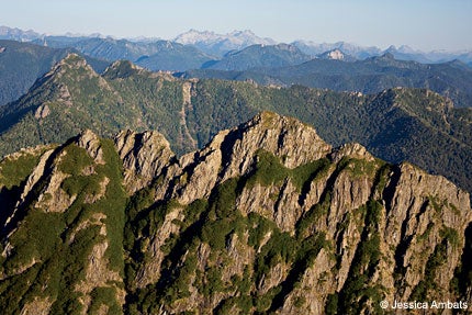
Your constant companion on the trip south was the Andes, a jagged and forbidding range of mountains that paralleled the western side of the continent, many reaching into the high teens and a few piercing the cumulonimbus at 23,000 feet.
As you drift south, you just might catch a glimpse of the famous Lines of Nazca. When I saw them for the first time, I was amazed at their size and complexity. Some cover entire mountains.
Despite what you may have seen on the Discovery Channel, the Nazca Lines are probably not the result of alien intervention to build runways for interstellar spacecraft. They're giant geoglyphs beginning 300 nm south of Lima that cover any semblance of flat or regular angled space. They're believed to have been etched into the ground between 400 and 600 A.D. by the Nazca Indians. Most portray everything from animals, spiders and birds to flowers, whales and lizards. Others seem to show semi-recognizable geometric shapes.
Arica, Chile, is the portal to the Atacama Desert, the world's driest. At its farthest north point, Chile is a narrow slice of desert that runs 1,500 nm down to Tierra del Fuego at the bottom of South America. In some parts of the Atacama, there has never been any rainfall recorded, but morning fog provides moisture for the animals and some plants.
For most aircraft headed to Argentina, Santiago, Chile, is the east-west crossing point of the Andes, but that doesn't mean it will be easy. The Pan American Highway climbs out of Santiago, winding up into the Andes with mountains towering four-and-a-half miles on both sides.
In fact, the highest peaks in the Andes guard the Pan Am road that crosses from west to east. To the north, Cerro Aconcagua reaches nearly 23,000 feet, and Cerro Tupungato, to the south, climbs 21,500 feet. Once, during a reverse delivery of a Cheyenne II from Mendoza to Fargo, N. D., I overflew a series of beautiful motionless nimbostratus roll clouds curling above the peaks for 500 miles from Mendoza to Antofagasta.
Fortunately, the pass between the two peaks tops at about 11,000 feet, so even most normally aspirated singles can struggle across the rocks without scraping off any paint. I've made that crossing a dozen or so times in everything from Cessna 182s and 207s to Caravans and the aforementioned Cheyenne, and the experience ranges from spectacular to terrifying, depending on what you happen to be flying. In one instance, trying to coax a very tired and heavily overloaded Cessna 206 high enough to make the crossing, I copied the moves of a condor climbing in free lift, before I broke out of the rising thermals and ran for the ridgeline before the mountains could suck me back down.
The Andes ridge marks the border between Chile and Argentina, and Mendoza, Argentina, is on the east side of the mountains. For the last 20 years, Mendoza on the north and Neuquen to the south have been centers for oil exploration. The Patagonian Desert southeast of Santiago and Mendoza has been under constant exploration by the French oil firm Schlumberger, along with America's Chevron and Dow Chemical. This has generated a major interest in utility aircraft that can carry heavy loads and land on relatively unimproved strips.
South of Neuquen, Argentina, there's not much except more Andes all the way to Cape Horn where the mountains dive beneath the infamous Drake Passage, remain submerged for 600 miles and resurface as the Antarctic Peninsula.
By any measure, South America is one of the most impressive of destinations. For the most part, it's safe and convenient, with few of the problems that plague so much of Africa and the Middle East.
I don't speak Spanish or Portuguese (some question if I even understand English), but South America has always been good to me. It's a destination that's close by and you need not fly over water if you'd prefer not.


Subscribe to Our Newsletter
Get the latest Plane & Pilot Magazine stories delivered directly to your inbox