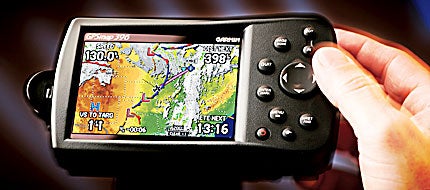
Garmin GPSMAP 396
The wunderbox that brings satellite uplink weather and radio capabilities to the cockpit
 Fourteen years ago, when I met Tim Casey of Garmin International, we were at the Paris Air Show, and Carl Pascarell and I had just ferried the prototype Sino Swearingen SJ30 jet across the Atlantic to Le Bourget Airport with little more than point-and-shoot VHF radios. Like most prototypes, the first SJ30 was having its share of systems problems, and electrical glitches had burned up both of our VLF/Omegas on the eastbound crossing. By definition, we were flying IFR above 35,000 feet and needed a method of positively identifying our position for the trip back to San Antonio, Texas.
In those days, Garmin was a new upstart company, mostly comprised of defectors from Honeywell Bendix/King, and no one could guess they would eventually become the world's largest GPS producer. Casey volunteered a then-new Garmin GPSMAP 100, so new, in fact, that it was an engineering demonstrator with a few teething problems. It had a relatively short battery life, somewhere between 15 and 30 minutes. The unit worked perfectly, but not for very long before needing a recharge.
Accordingly, I used the Quick Fix mode to plot single positions on our return flight, marking them on a chart and regulating the heading accordingly. Repetitive position is, after all, the most important function of any GPS, and even the first prototype GPS 100 did that very well. Pascarell and I brought the then-$40-million business jet back across the Atlantic, using an $1,100 portable GPS.
Now, suddenly, it's 14 years later, and Garmin's technology has leaped so far beyond that first GPS, it's as if there have been 140 years of evolution. Interestingly, despite dramatic improvements in the state of the art, the price for a basic GPS has declined. You can now buy an excellent moving-map product for the same as or less than what you paid for a GPSMAP 100.
The company's latest portable aviation product is the handheld model GPSMAP 396, an XM WX-enabled, direct follow-on to the color GPSMAP 296 from 2004 and the monochrome GPSMAP 196 from 2002. Just as the GPSMAP 296 brought terrain awareness to portable GPS, so the GPSMAP 396 introduces satellite uplink weather. The new unit retails for $2,695, including mounts, antennas and virtually everything else you could ask for.
XM Radio charges increase the ante. Satellites aren't cheap. These include a one-time setup fee of $75, then $29 per month for the basic service, or $49 for the full package. If you want XM Radio, expect to pay an additional $6 to $12, depending on the package you decide to get. In other words, opt for the full package, and you'll pay $75 up front, plus about $750 per year in subscription charges. The full service provides a major list of services, plus it's portable. More on that later.
Casey recently loaned me the GPSMAP 396 in conjunction with a summer trip from Indiana to Alaska and back with Dr. Bill Grider of Kokomo, Ind. The GPSMAP 396's XM WX uplink weather employs a pair of satellites (appropriately named Rock and Roll; remember, this is a product of XM Radio) in geosynchronous orbit above opposite coasts in North America, providing 24-hour coverage throughout the U.S. XM WX laps over into Mexico and Canada, and on our flight north, we ran out of coverage just north of Dawson Creek, British Columbia. Still, there's 2,000 nm between Indiana and the Yukon, so the XM WX feature gave us welcome warnings of weather and winds ahead.
XM WX may be the best thing that has happened to instrument flying since the HSI. Garmin's Matt Burch went out of his way to keep the system as intuitive as possible, and the result is a GPS product that a 14-year-old could probably figure out without a manual. (In fact, a typically computer-savvy 14-year-old might play a GPSMAP 396 better than most adults.)
Perhaps the best news is the ease with which you can move between weather pages. All mode icons---GPS, Weather, XM Radio, Flights, Route, E6B, etc.---are on the far left side of the menu page. You merely select "Weather" from the menu section, then cursor right with the rocker key and page up or down through the various XM Weather products. Once the system is locked on (you'll sometimes receive the "Waiting for Data" warning for a few minutes after startup), you can page between the data choices in seconds.
The system provides weather coverage in near real-time. At worst, NEXRAD information is no more than five minutes old. When Dr. Grider and I left Kokomo, we monitored storms over the Northern Plains states several hundred miles away and watched the weather develop and march to the southeast. On the larger scales, we could even scroll back 800 nm to the Gulf of Mexico and check the storm situation. We also interrogated the system for winds aloft at our breathable altitudes, but we could have checked for winds as high as 42,000 feet (in 3,000-foot increments) if there had been a need. This allowed us to make informed decisions about the best height for winds. You can even loop the weather, although only for a few radar sweeps because of limited memory (64 megabytes), so movement trends aren't that evident.
In addition to high-resolution NEXRAD, satellite weather mosaic views and winds aloft, XM WX includes another dozen or more products. These include METARs, TAFs, AIRMETs, SIGMETs, along with the ever-changing TFRs, the latter an especially valuable feature at a time when the FAA is liable to establish a new TFR or extend an old one on the spur of the moment. Other XM products include Echo Tops, precip type, freezing levels, surface pressure, and city and county forecasts. There's an electrical storm track page and a lightning strike page in case you need to monitor severe weather in the area.
The GPSMAP 396's obvious primary benefit is its weather uplink, but the system has other talents besides weather coverage. The new Garmin portable expands on the GPSMAP 296's TAWS capability by adding aural warnings of terrain ahead. Garmin's awesome 30-arc second database encompasses all the standard aviation points plus all man-made or natural obstacles and a terrain data point for roughly every half-mile of North America (30 million in all). That means four terrain data points per square mile. With this much terrain information available, the new GPSMAP 396 can serve nearly the same functions as an airline TAWS at a fraction of the cost.
Additionally, the GPSMAP 396 is modestly programmable. You can choose some parameters of warning limits. If the system senses terrain within those limits, a small thumbnail box will pop up at the lower left, and you'll hear Garmin's British-accented Betty warn of "terrain, terrain." The GPSMAP 396 also alarms on excessive descent rate and warns of any terrain within 500 feet with the traditional "pull up, pull up."
Like the earlier GPSMAP 296 (see "Tech Talk: Garmin GPSmap 296," P&P, September 2004), the GPSMAP 396 offers a vivid, color, moving-map display, but unlike the earlier model, the new system is far more resistant to wash out in bright light. It's a full 70% brighter than the screen used on the previous model. That's a major improvement as, despite the GPSMAP 296's other talents, the moving-map display can become difficult to read in bright-light situations. The GPSMAP 396's 480 x 320 display is clearly visible in virtually any light without losing map detail. Garmin says backlighting has been improved, and the new screen reduces reflectivity, but the bottom line is a more vivid, easier-reading display.
A nice combination feature of the new box and XM WX is the series of enhancements to the "nearest airports" feature. Now, when you select "Nearest," you can interrogate for weather at each of those closest airports. If you need to divert, it's easier to make a quick decision as to which alternate is the best choice. Similarly, the "nearest airports" feature enables another valuable asset for normal flying. The system can provide the altimeter setting at the airport closest to your current position.
Another nice feature of the GPSMAP 396 is its ability to interface with the Garmin SL30/40 navcoms. When coupled with either box, the GPSMAP 396 can display an automatic upload of communication frequencies on the standby window. If your airplane is equipped with a Garmin 330 mode-S transponder, the 396 can be coupled to the 330 to display traffic uplink, although it's likely most 330 owners are already reading traffic through a Garmin GNS 430 or 530.
(A company called Air Gizmo has developed a clever mount that allows installing a GPSMAP 296 or 396 directly in the radio stack rather than on the yoke or on top of the panel. Although intended primarily for the homebuilt market, the Air Gizmo GPS Panel Dock could work equally well for a variety of production airplanes.)
Vnav capability has been enhanced as well---at least it's now easier to use. On the GPSMAP 296, Vnav descent guidance was only available on the HSI page, so you were required to select that page in order to monitor vertical progress. That wasn't such a bad thing, except that most pilots probably fly with the moving-map page most of the time. Now, Vnav also plays on the moving map, with a drop-down glideslope bar on both sides of the display.
Finally, on a less serious note, there's always XM Radio, providing 150 choices, including everything from rock to classical music. As you might have guessed, XM is heavy on rock, featuring hits of the '50s, '60s, '70s, '80s and '90s, plus every possible variety of acid and puke (sic) rock, but there are a few channels dedicated to classical, jazz, country and a variety of alternative music options. Inevitably, there are several talk options and a few news choices. No matter what your taste, you'll probably find something to accommodate it. You can either listen through an interconnect to your audio system or, if you have a really quiet airplane and order the auto kit, through the tiny speaker provided with the GPSMAP 396's power plug.
Once you've selected a channel, you can adjust the volume to a comfortable level, return to a weather or GPS page and have the music play in the background as long as you like. ATC communications will, of course, override Howard Stern or music.
Remember, too, that the GPSMAP 396 is a portable unit and may be transferred to your car, boat or off-road vehicle when you're through flying for the day. Garmin provides an excellent beanbag mount that resists movement more than you'd believe and works as well on the dash of a car or boat as it does on top of an instrument panel. You can even hook up the GPSMAP 396 to a home stereo system, although you'll need to mount an outside antenna.
The GPSMAP 396 is so talented that you have to wonder if it might cut into Garmin's more upscale products, the GNS 430 and 530, and GDL 69 Jeppesen Weather Data Upload. The tab for a GNS 530 enabled with a GDL 69 is just north of $20,000, and the GPSMAP 396 offers its own version of the same talents for a little over a tenth of the price. Of course, despite its considerable sophistication, the GPSMAP 396 obviously isn't IFR-approved, has no communications capabilities and isn't quite as sophisticated as the top-panel mounts.
Still, the Garmin GPSMAP 396 incorporates a staggering amount of capability for less money than you would imagine. Consider that with a single GPSMAP 396, a 330 transponder and a basic VHF navcom, a pilot can enjoy the full benefits of a 12-channel GPS, ILS and VOR navigation, traffic uplink, XM WX and terrain warnings. That's an awesome package of talent.
For more information, please visit www.garmin.com.

Subscribe to Our Newsletter
Get the latest Plane & Pilot Magazine stories delivered directly to your inbox


