
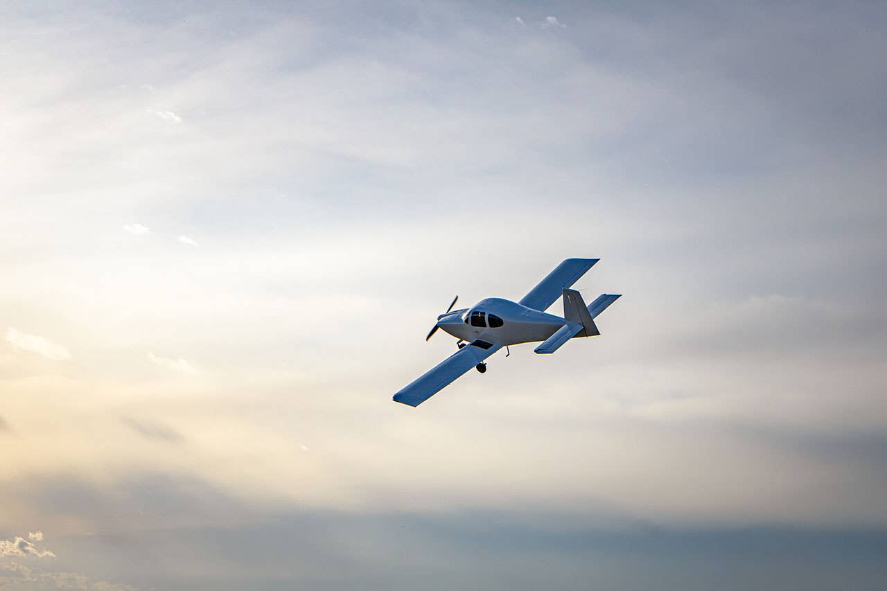
 As pilots, we're used to flight planning. Flights are usually straightforward and easy to plan, but occasionally, they involve multiple legs and traversing congested or complicated airspace. Longer flights require more-than-normal flight planning. I recently completed a 1,600-mile flight in my Garmin G1000--equipped Columbia across seven western and midwestern states and three time zones. It was apparent to me that, to do it right, longer flights entail more than just sitting longer en route and making additional fuel stops, particularly when the flight is more than 1,000 miles.
Is George Healthy?
Let's begin with a simple premise. We all know that single-pilot flying, especially in IFR conditions, can be tough going: A working autopilot is a critical component to safe long-distance single-pilot flight. When you're contemplating a 9-, 10- or 11-plus-hour flight---much of which might be in IMC---having your favorite electronic copilot onboard and performing at 100% can be crucial to a comfy and safe flight. Garmin's G1000/GFC 700 is one of the best autopilots in the business.
Planning Is The Key
The first step is to plan the flight---the routing, intermediate stops and alternate airports---in case you need a Plan B. Depending upon the weather, you should even consider preplanning your route for Plan B!
Sometimes, flying slower can mean a quicker and less expensive trip. Most new-aircraft POHs provide a range of power-setting options, so it's possible to choose one that requires only one stop or even no stops. In my Columbia, operating lean of peak at 82% of rated power means that, at 16,000 feet, I can cruise at 209 KTAS using 18 gph. By reducing power to 51%, the cruise speed slows to 174 knots, the fuel consumption is reduced to 12 gph, and the range increases from 803 miles to 1,143 miles: That's an increase of 340 miles. Comparing those power settings for a 1,000-mile trip, the lower power setting would take about an hour longer, but would consume about 17 gallons less. Because of the time it takes to descend, refuel and return to altitude, the slower flight would probably take less total time.
When picking intermediate airports for refueling stops, use one of the airport information websites (such as www.airnav.com) to find the best fuel prices. I've recently seen almost a $3 difference in 100LL at airports located fairly close together, so if you want to be fiscally responsible, plan ahead. Often, smaller airports located near major airports will have better prices than the larger airports.
One trick to remember when picking a refueling airport is to select one that's at a higher elevation. You may spend less time descending and climbing back to altitude for the next leg. You should also keep the airport's density altitude and runway length in mind, particularly if your aircraft will be operating near the edge of its performance envelope.
 |
If you fly in the western United States or in mountainous terrain, pay particular attention to MEAs. On some legs, you often can find more than one airway that goes to the same place. One airway may have a much higher MEA than the other, while the airway with the lower MEA may be longer. Pick the airway that's appropriate for the weather, the aircraft and your passengers.
Speaking of passengers, keep their comfort in mind. It might be possible to string a couple of long legs together, but your passengers may appreciate a trip broken into additional legs. On a recent eastbound trip, my first leg was 4.5 hours followed by one five-hour leg. For the westbound return trip into the expected headwind, I added an additional stop, and the legs ended up being 3.6, 3.3 and 3.3 hours. Shorter legs can make for much happier passengers.
If your trip requires an overnight stop, make a hotel reservation before departing. You can use AirNav's website to review local accommodations, or you can call the local FBO. If you have to divert, the local FBO can usually recommend accommodations and will often provide an airport car or transportation.
 |
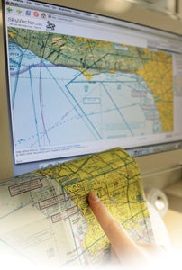
| When preparing for your long-distance flight, utilize online resources to make flight plans and check the weather on your planned route. |
Weather Or Not?
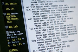
Watch The Weather Channel and/or follow other preferred weather services as the departure day approaches. The day before, get an "outlook" briefing for the full trip. The easiest way to get a full route briefing is to ask for an outlook briefing for a combination of all the legs---essentially, you'll request weather for a nonstop flight. Combine the routes, airways and waypoints for all of the legs, making sure that the routing is ATC-computer compatible. Total the flight and ground times for the full trip to indicate the total en route time and get a full briefing. Once you have the primary briefing, ask for forecasts at your planned refueling stops. This day-before overview saves you from having to do individual briefings for each leg.
The day of the flight, you'll get a full briefing for each leg; while you're at it, it makes sense to file the flight plan for each leg. You could get a weather briefing and file a flight plan at each stop, but instead, consider filing all flight plans the night before and then getting your weather briefing for the next leg from the FSS while en route. If you need to change any of your flight plans (e.g., a departure has been delayed), and you filed through one of the services (e.g., DUATS or DUAT), your flight plan won't be available for modification by an FSS or ATC until the provider sends it to Center's computer. To provide greater flexibility for multistop trips, file all flight plans through an FSS.
Because you might pass through multiple time zones, determining departure times for each flight plan can be problematic. Going east, you'll lose an hour crossing most time zones, while going west, you'll pick up an hour. (Arizona chooses not to honor daylight saving time so that can be confusing. Consider using GMT for all flight plans; that should resolve most issues.)
Be Prepared
You need to be prepared for IFR conditions on any long flight. If you aren't an IFR-rated pilot, then prepare for a diversion. Ensure that you have the appropriate VFR charts; WACs will usually suffice, but you might want a sectional for your refueling stops and destination. If you are IFR-rated, carry instrument en route and approach charts, even if the weather is forecast to be VFR. It's smart to carry charts for a wider area than you intend to fly, as you may find that the weather forces you into a routing you didn't expect. It can be stressful to be en route to an alternate airport and realize that you don't have charts. Don't count on finding the charts you need at an en route FBO either; you should have them onboard before you start the trip.
A strong case can be made for carrying a survival kit on every flight, but for a long flight, especially across inhospitable terrain, it's a necessity. It doesn't have to be expensive or huge, but it should cover at least the basics, such as water, first aid and environmental protection (e.g., blankets and sun block). I carry much more than that on every flight.
Make sure you and your passengers are prepared for a long day of flying. Carry sufficient liquids---water would be the preference---and encourage your passengers to drink. Eat well before you depart and carry sandwiches or some other convenient healthy food (not sweets) as well. Your body will appreciate it, and you'll be much sharper at the end of the day. You should also carry whatever personal relief products you prefer.
If you're flying in mountainous terrain, then you'll need or at least benefit from oxygen, especially if you're planning to spend any time higher than 12,000 feet. Take your passengers into consideration: Some people can get bad or severe headaches even at altitudes below 12,000 feet. Supplementary oxygen helps. Breathing oxygen periodically, and especially in preparation for the descent and approach, will make you sharper and less prone to mistakes. Everyone can benefit from continuous or at least periodic use of oxygen on a long flight.
On The Road Again
Sure, you obtained a weather briefing and you're prepared to begin the flight, but much of the time, the weather won't be as forecast. For almost all long-range flights, weather becomes a tactical problem at some point. Use Flight Watch if you have no other options, but if you have an airplane with a Garmin 396, 496 or G1000, XM Satelite Weather can prove a lifesaver. The variety of weather data available is truly outstanding. [See the "Garmin G1000: Cross-Country Tips" sidebar for some useful tips.]
On a recent trip, all of the usual weather sources indicated that the Midwest was looking pretty risky, and the briefer specifically stated that an IFR flight might be difficult. I've flown western and midwestern states enough to know that the forecasts don't necessarily paint the full picture. On this trip, although I was IMC and in rain for protracted periods, when the weather looked iffy, I was able to remain VMC by deviating. From the start of every trip, I use the G1000's weather display to periodically check the weather at my final destination. On my trip, it rained at my destination throughout the entire day. Being aware of the weather was very useful because it encouraged me, while I was dodging thunderstorms, to think long and hard about Plan B. Luckily, when I arrived at my destination eight hours later, the rain had abated to light showers.
Any time you fly long distances, especially in the summer, you can expect convective activity. Many articles have been written on how to deal with thunderstorms, and the new weather displays certainly take some of the worry out of it. The smart pilot's trick is simply to avoid thunderstorms entirely, and the best way to do that is to remain VMC for as long as possible. You'll find that most controllers who operate in areas with convective activity will honor almost any request for deviations. If you need to deviate, ask for it early and try to fly upwind of the weather. Even though the frequency may be quiet, controllers often are busy on other frequencies, so ask early. Asking at the last minute might have you staring at a large dark cumuliform cloud with the chance of escape decreasing rapidly. You're pilot in command, so you should use your authority to deviate if necessary. Just make sure you inform ATC.
A Long Way Home
Once you've successfully completed your trip, you only have one more objective: flying home. All of the flight planning needs to be done in reverse. The good news is that, for the most part, you can usually just reverse the original route. But weather can require different routing, so bring along all of your flight-planning tools. There's great pleasure in completing a long and potentially difficult trip successfully. Airplanes are made to fly, so look at a map of the country and start planning!
| Garmin G1000: Cross-Country Tips When flying cross-country, the most important variables are weather and its effect on aircraft range. The Garmin G1000 provides some very useful tools to help manage both. |
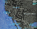 1) USE WINDS TO YOUR ADVANTAGE Weather briefings provide localized snapshots of forecast winds. Often, that isn't good enough for an en route response to actual weather. The G1000 with XM Satellite Weather makes it a snap to visualize winds and determine the best altitudes and routings to benefit from them. Using the soft keys on the Weather Map page in the MFD, select Winds and the appropriate altitude, and you'll be able to see a depiction of the prevailing winds. If you increase the map's range to include your destination, you'll have a sense of how to utilize winds or at least minimize their effect throughout the full trip. 1) USE WINDS TO YOUR ADVANTAGE Weather briefings provide localized snapshots of forecast winds. Often, that isn't good enough for an en route response to actual weather. The G1000 with XM Satellite Weather makes it a snap to visualize winds and determine the best altitudes and routings to benefit from them. Using the soft keys on the Weather Map page in the MFD, select Winds and the appropriate altitude, and you'll be able to see a depiction of the prevailing winds. If you increase the map's range to include your destination, you'll have a sense of how to utilize winds or at least minimize their effect throughout the full trip.
|
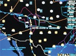 2) STAY AHEAD OF THE WEATHER Once you've begun your flight, your best bet is to focus on each leg, but don't forget the remainder of the trip. Set the Weather Map page on the MFD to display the appropriate types of weather information using the soft keys, and then increase the map's range to include your destination. You'll be able to see cells, fronts, AIRMETs and SIGMETs, etc. all the way to your destination. You don't want to use the information to thread the needle through a gap in a front, but it can help you to make early routing decisions to avoid undesirable weather. For example, you can use it to stay upwind of cells, to take advantage of wind circulation around highs and lows, and to avoid areas with significant weather.
 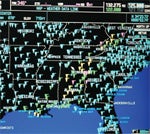 3) KNOW SURFACE WEATHER CONDITIONS The G1000 gives you a simple way to keep an eye on weather conditions near your aircraft and along your route of flight. Once again, configure the Weather Map page using the soft keys to show the METAR status for all airports that report ATIS, AWOS or ASOS. The color of a triangular flag by each airport icon indicates whether the airport is VFR, MVFR, IFR or LIFR. Increase the map display range to somewhere between 50 and a few hundred miles, depending upon the speed of your aircraft, and the flags will give you a general sense of the surface weather conditions throughout the area. You can even scroll the map to the area around your destination airport to get an overview of weather conditions on the ground near your destination.
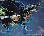 4) USE THE FUEL RANGE RING TO HELP MANAGE FUEL Improper fuel management is one of the most common causes of aircraft accidents. The G1000's Fuel Range Rings can prevent accidents from fuel exhaustion. From the MFD Navigation Map page, press the Menu soft key, press ENT for Map Setup, choose the Map group, and then change FUEL RNG to ON---two Fuel Range Rings will be displayed on the MFD Map page. The inner ring shows the remaining distance to reserve fuel, and the outer ring shows the remaining distance to empty tanks. The default reserve fuel time is 45 minutes. Change the time to reflect your personal minimums (think at least one hour). If your destination is outside the reserve fuel ring, then you don't have enough fuel to meet your minimums. You can either divert or reduce power to see if the lower power setting and lower fuel consumption will allow you to land with appropriate reserves.


Subscribe to Our Newsletter
Get the latest Plane & Pilot Magazine stories delivered directly to your inbox