
Making ADS-B Work
The technology looks promising, but there are still unanswered questions about its implementation
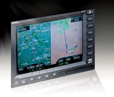 |
| The split screen function on the Garmin MX20 allows the pilot to view the regular moving map with all traffic overlaid and navigational information (left), and a graphical weather display overlaid on a basic moving map (right). |
When it comes to owners being told they must install expensive new equipment in their planes, it's always better to offer them more carrot and less stick as an incentive. For now, the FAA's proposed mandate on Automatic Dependent Surveillance-Broadcast (ADS-B) is looking like too much stick and too little carrot.
Since it began as the Capstone Project in Alaska, ADS-B has held the promise of delivering critical traffic and weather information into the cockpits of even the smallest general aviation (GA) aircraft. When Capstone ultimately proved its worth, the FAA opened the door for pilots in the Lower 48 to share the wealth.
The "East Coast deployment" wasn't just a trial run, but a broad-scale program that still provides ADS-B coverage for almost all areas from eastern Pennsylvania to southern Florida. The project proved that near real-time weather and comprehensive traffic information could be delivered via datalink in an easy-to-use format that enhanced safety in two critical areas: traffic avoidance and weather depiction with forecasts. It also held the promise of replacing some ground-based ATC facilities with satellite-based surveillance.
Demonstration programs, such as the North Carolina Division of Aviation's three-year effort, enabled thousands of aviators to get a firsthand look at what ADS-B delivers---almost everybody came away singing its praises. They loved the easily accessible Flight Information Services-Broadcast (FIS-B), which offers NEXRAD images, METARs and TAFs, and Traffic Information Services-Broadcast (TIS-B), which allows pilots to view all traffic squawking a Mode C transponder code or equipped with ADS-B transceivers. For those who witnessed ADS-B in action, there were usually two questions about its future: 1) When will it be available everywhere? 2) How much will it cost?
The FAA responded to the results of the demonstration projects by putting together a diverse group of technology advocates and potential vendors and laying out a plan for national deployment. It prepared a road map for how the system could be built, then initiated the bidding process for a vendor to install the national infrastructure. In 2007, ITT Corporation (www.itt.com) was announced as the prime contractor for the massive installation. ITT is heading a consortium that's already preparing to expand the system; the goal is to provide nationwide service by 2012, and new ground stations will be installed as early as late 2008.
John Kefaliotis, ITT's director of business development, describes his company's role: "ITT is under contract to the FAA to field a national infrastructure that facilitates the full range of ADS-B services. Our infrastructure will collect ADS-B ’Out' data, forward that data to FAA ATC facilities and broadcast data for ADS-B ’In' applications, i.e., TIS-B and FIS-B. These are the first services to go online [in addition to the existing ’legacy' equipment], with the southern Florida key site ’In-Service Decision' date scheduled for November of this year."
At the same time, the FAA was preparing its required notice of proposed rulemaking (NPRM), designed to generate public comment from interested parties, including such key advocacy organizations as AOPA, EAA and AEA (Aircraft Electronics Association). Once the NPRM was issued, those responses were overwhelmingly less than enthusiastic.
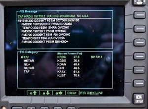 |
| Text weather, including METARs and TAFs, are available on the FIS-B page of the Garmin MX20. |
Almost universally, the criticism was based neither on the timeline for ADS-B adoption nor on the overall concept, but instead on the FAA's insistence on mandating ADS-B Out, a decision seen by many as primarily offering the FAA a way to lower the cost of providing ATC services, while requiring the owners of GA aircraft to shoulder the financial burden.
To better understand the widespread opposition to the mandate as currently written, a quick comparison of ADS-B Out and ADS-B In is in order. The GA pilot who has only ADS-B Out will see few, if any, benefits over those provided by the current Mode-C-transponder-equipped aircraft. Those with ADS-B In, which also will automatically include ADS-B Out, will have complete access to datalink weather information, including radar images, surface observations and forecasts, plus detailed traffic information. In other words, with ADS-B In, pilots will have useful tools that greatly enhance the safe conduct of flight. With just ADS-B Out, pilots will simply be allowed to do what they're already doing, but will have to equip their aircraft with an expensive new box to maintain the status quo. As with the adoption of any new technology, for all parties concerned, it all comes down to cost versus benefits.
If you spend the time to wade through the NPRM, the FAA's position seems to be simple. They'll provide all services (ADS-B In and Out) and let owners choose which version to install, but with a critical provision. Under the mandate, by 2020, owners must install at least ADS-B Out in aircraft they plan to fly in controlled airspace (in essence, this includes the majority of GA aircraft). Organizations and individuals who have studied or already used full-featured ADS-B services argue that this mandate offers no new benefits for owners and penalizes them by requiring new equipment.
"The ADS-B proposal is a good starting point for deliberation on the implementation of this cornerstone for the NextGen [Air Transportation System]," wrote Andy Cebula, AOPA executive vice president of government affairs. "However, the proposal isn't acceptable in its current form. The implementation plan offers little benefit to GA operators. The FAA's contract for ADS-B services leaves GA wanting; incentives are needed for ADS-B equipage."
The AEA weighed in similarly, "The AEA, in general, supports the requirement to adopt ADS-B. However, the AEA doesn't support this proposed regulation. The FAA has failed to offer a proposal that's cost-effective and safety-enhancing, or even a complete proposal," said AEA President Paula Derks. "In addition, contrary to public law, the FAA is proposing a performance standard in this NPRM that isn't available for the public to review."
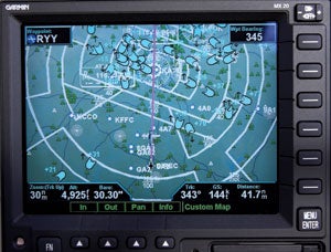 |
| The ADS-B traffic display as seen overlaid on the moving map of a Garmin MX20 MFD. Shown here is a high concentration of traffic over Hartsfield-Jackson International Airport in Atlanta, Ga. |
Doug Macnair, EAA vice president of government relations, commented, "Most of the benefits cited in this NPRM either don't apply to GA at all or are derived from technologies already being embraced and fielded by GA pilots and aircraft owners on their own, such as moving map and GPS. The FAA didn't consult with the GA industry in developing this implementation proposal, and it shows. Under this proposal, the agency is dramatically shifting the costs of the National Airspace System from FAA ownership and operation of ground-based ATC surveillance technologies to the individual aircraft owner---to the tune of many billions of dollars."
Again, it all comes down to money. As the plan is currently written, owners will have the choice to pay a smaller amount to satisfy the requirements of the ADS-B Out mandate, or pay for a more expensive installation that will provide them with full weather and traffic information. At this time, it's difficult to accurately project the cost for either option based on current equipment availability. But that may change very soon.
Beginning with Capstone, the avionics box at the heart of ADS-B has been manufactured by Garmin. It's designed to handle both ADS-B In and Out signals and is called the GDL 90 UAT (Universal Access Transceiver). So far, it has been manufactured in such limited numbers that it's very expensive, and coupled with the need for a Garmin display unit such as the GMX 200 MFD, the total installation cost has approached $20,000.
Now, with the FAA's commitment to ADS-B, other vendors will soon compete with Garmin by providing both transceivers and cockpit display units. A key vendor already hard at work on its own ADS-B system is Sandia Aerospace, part of the consortium assembled by ITT. Sandia President Dennis Schmidt says, "Sandia Aerospace will introduce an ADS-B system in mid-2009 with an attractive price point at or below $3,500. Our introduction timing corresponds with ITT's network availability across most of the United States, while our price point and feature set address the main concerns voiced in the GA community. Our system will interface with a wide variety of display units, and we're working with display manufacturers now to ensure interface compatibility."
Sam Seery, Garmin's marketing manager says, "The real benefit comes with ADS-B In- and Out-capable avionics. The pilot's situational awareness is dramatically increased with a display of proximate traffic in the air and on the ground and graphical weather. ADS-B In and Out avionics will provide reduced separation standards that improve efficiency in busy airspace, saving time and fuel. Several advanced applications are being discussed and are possible only for operators who equip their aircraft with ADS-B In and Out avionics."
For owners weighing their choices, the carrot in the equation is that prices should come down, and they'll have the option of flying with greater weather and traffic information than ever before. Plus, they still have a lot of time to wait and see what becomes available before being forced into a decision.
The FAA offers more info on ADS-B at www.adsb.gov, and Mitre Corporation, a nonprofit group that does research on ADS-B for the FAA, offers more at www.caasd.org/work/airborne_systems.cfm.
| Three Years Of Real-World ADS-B Flying |
|
For the past three years, several hundred pilots across the United States have experienced what it's like to fly with ADS-B, and I've been one of them. My 1949 Ryan Navion was one of the first (if not the first) privately owned aircraft in the Lower 48 to have the new technology. I agreed to participate in a three-year project created by the North Carolina Division of Aviation to demonstrate that the system that had worked so well in Alaska's Capstone Project held the same promise everywhere. With the other fortunate owners in the project, I committed to flying demo rides on a regular basis and reporting the results of how I used the weather and traffic services in my day-to-day flying. After almost three years of flying with ADS-B, my early impressions are still the same: I'm now spoiled and wouldn't want to fly without it or a comparable service in my airplane. And since there's no other single-source, nonsubscription service that compares, I wouldn't want to fly without ADS-B. To help me avoid the many planes that are never identified as traffic by ATC, I've come to rely upon the TIS-B that overlays a display of all traffic squawking a Mode C code onto my moving map. This is especially critical in high-density areas, such as the busy corridors through the Washington-Philadelphia-NYC airspace and along the coast of Florida. But it has also been surprisingly useful in so-called low-activity areas around uncontrolled airports, including my home field with its near-constant mix of student training, private pilots and corporate traffic. ADS-B's FIS-B has allowed me to see nearby and distant NEXRAD images that have proven invaluable in making in-flight decisions. Coupled with my ability to get detailed METAR and TAF information for en route, destination and surrounding airports, I no longer have to depend on outdated preflight information or interpret an audio-only report from Flight Services. The result? In demanding weather conditions, I can "see" what's ahead, and instead of landing to get an update on an FBO weather computer, now I complete more flights with greater awareness and confidence and less stress. Are there things I don't like about ADS-B? Yes, I still have a problem with having to use a split screen to display the relatively crude FIS-B graphic weather page along with my normal moving map with its excellent terrain, airspace and navigation information. But from what I understand, with newer display units with more processing power than my five-year-old Garmin MX20, that's a problem that will disappear. The limited coverage area has also been a problem, but that will no longer be a concern as ITT quickly begins to expand the network outward from the East Coast area, leading to nationwide coverage by the end of 2012. |


Subscribe to Our Newsletter
Get the latest Plane & Pilot Magazine stories delivered directly to your inbox