Departing IFR Without Guidance

When ATC is unavailable and you need to guarantee your own separation from terrain, do it carefully.

Even a modest climb is normally good enough to easily meet the requirements for a diverse departure procedure. But its up to pilots to be sure that they can stay within the zone of safety before joining up with an airway or getting a vector from ATC.

Many VFR-only pilots are familiar with how instrument approaches offer the safe paths that take us from the air to the ground. Each approach gets a snazzy chart, rich with black lines, zigging arrows and lots of numbers, and the skill at decoding said charts is a time-honored right of passage into the IFR illuminati. 

New IFR students also learn there is departure equivalent from some airports called the Obstacle Departure Procedure (ODP) designed to get them safely around obstacles on their journey from the runway to the sky. ODPs are rarely charted. Instead, they are published in a somewhat cryptic text that requires study and visualization, plus cross-reference to instrument Enroute Charts (the IFR equivalent of the Sectional Chart) to really work out. 

It's like they're a test: If you can read this and depart without killing yourself, we'll let you in the IFR club and provide radar services to your destination. If not, well, at least we weeded you out at the beginning of the flight.

What's confusing to many an IFR inductee is what to do when the airport doesn't have an ODP. You're standing on the ramp looking at the low overcast skies and thinking, "I know there's stuff out there somewhere, yet there's no procedure to avoid it. Can I just take off and climb without worrying about it?" 

Well, almost, but not entirely. 

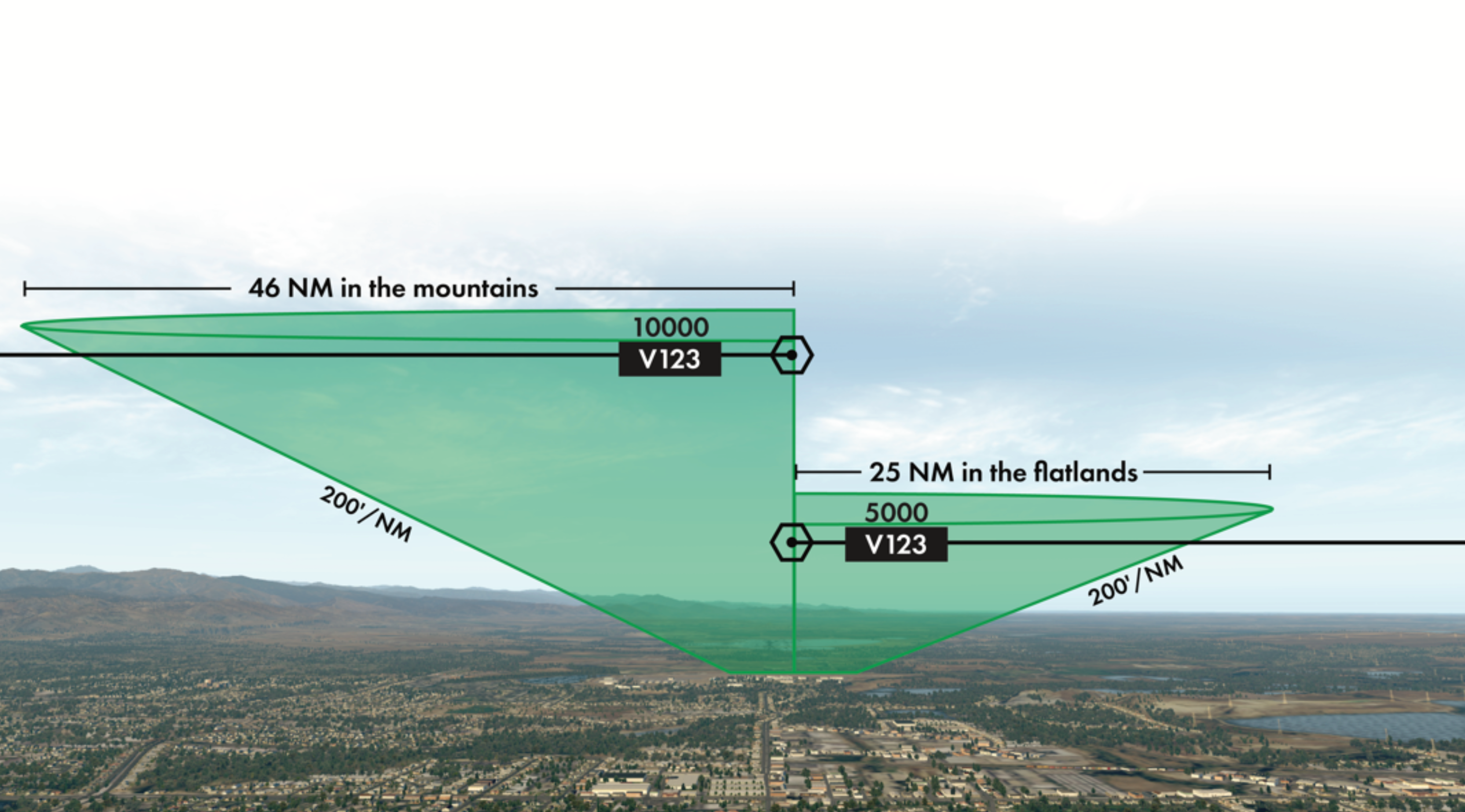
The first question you must ask when departing is whether the airport you're departing has at least one published instrument approach. If so, the airport has been surveyed for obstacles on departure as well. Unlike an approach where the designers have to find just one viable path to the runway, you could potentially go any direction on departure, so the survey team evaluates a full 360-degree cylinder of space around the airport. If they discover unyielding, aircraft-eating objects, they publish an ODP. If not, the airport qualifies for a diverse departure.

The diverse departure is the default IFR departure procedure. That is, if you haven't been assigned a departure procedure in your clearance or a departure instruction from ATC, and there's no ODP published for your airport, and the airport has at least one published instrument approach, then you can take off and climb on course as cleared, provide you meet a few requirements.

The first one is trivial for most aircraft: You must fly runway heading to at least 400 feet AGL and cross the departure end of the runway at least 35 feet AGL. All IFR departures, be they published, diverse or by ATC instruction, begin that way. 

Diverse departure procedures are used at airports where there's no Obstacle Departure Procedure published and the terrain and other obstacles around the airport allow it.

Above 400 AGL, the diverse departure lets you continue the climb in whatever direction takes you on course, provided you continue to climb at least 200 feet per nautical mile. That's feet per mile, not feet per minute. If you climbed at 60 knots, which is 1 nautical mile per minute, it would be a climb of 200 feet per minute. But if you climb at 120 knots, you need 400 feet per minute. What matters is groundspeed, not airspeed, so even a Cessna 172 with a bit of tailwind could need at least 400 feet per minute. Therefore, the safe zone for a diverse departure isn't a cylinder of airspace around each airport so much as an inverted cone, albeit a pretty shallow one.

Most discussions of diverse departures end there, but that omits one last requirement. The diverse departure doesn't extend infinitely in every direction around the airport. This cone of safety only extends 25 nm in non-mountainous areas and 46 nm in mountainous ones. If you fly a diverse departure, you must reach a known safe instrument altitude before getting more than 25 nm (or 46 nm in the mountains) away from the airport. 

A safe instrument altitude means an MEA for an airway you're joining, which is shown on the chart along the airway, or the off-route obstruction clearance altitude (OROCA) for the sector you're in. OROCAs are the IFR counterpart for the brown Minimum Elevation Figures (MEFs) you see for each quadrant of a Sectional Chart. MEFs provide as little as 100 feet of obstacle clearance. OROCAs provide at least 1000 feet, so the published altitudes are higher. 

Even climbing only 200 feet per mile, after 25 miles you'd be 5000 feet AGL. By the time you traveled 46 nm from the airport, you'd be over 10,000 feet AGL. You're also only concerned about maintaining your own obstacle clearance until getting a vector from ATC, at which point they take over that responsibility. However, just hearing "radar contact" doesn't constitute a vector, so it behooves you to understand these details and ensure you have a plan to get from pavement up to altitude entirely within the protected airspace.

Sometimes the airport would qualify for the diverse departure if the airplane could climb just a little bit steeper for the first thousand feet or so. Or 200 feet per nm would work if the airplane could see and avoid that one annoying cell tower before entering the clouds. Adding such a restriction and then saying it's good for a diverse departure from that point would be so much easier than creating a whole ODP. 

So there's one more thing to check: the Takeoff Minimums. The most common format is that you need a certain ceiling and visibility to see and avoid obstacles while you climb at least 200 feet per nm, or you need a climb rate greater than the standard 200 feet per nm until a certain altitude, after which you can continue to climb at the 200 feet per nm.

Technically, complying with takeoff minimums or following published ODP isn't required for Part 91 flight. However, I like to treat these restrictions as if they are required, because I'm a member of the Pilots Who Like Continued Birthdays club. Besides, my tax dollars paid for that obstacle survey, and I'm going to use it, dammit.  

On VFR charts the MEFs provide scant clearance for obstacles. By using OROCAs, which build in more margin, pilots can provide themselves with safer assumptions while joining published routes near the airport.

Let's put it all together departing Houlton, Maine (KHUL) and using the bigger runway of 05-23. This airport has two instrument approaches, so it's been surveyed for departures. Runway 05 has no published departure procedure, which means we'd use the default procedure of fly runway heading until 400 AGL before making any turns. Runway 23 has a departure procedure: Climb heading 229° until 1000 feet before any left turns. Houlton's elevation is 489 feet, so even that's only a climb to 511 feet AGL. 

However, Runway 5 requires 300-foot ceilings 1.5 miles of visibility if you can only climb 200 feet per nm. If you want to take off with less than that, you should be able to climb 340 feet per nm to 900 feet (411 feet AGL) before continuing to climb at 200 feet per nm. Departures from Runway 23 require higher ceilings and a higher climb rate of 389 feet per nm up to 1000 feet. That's 778 feet per minute with a groundspeed of 120 knots, or 584 feet per minute at 90 knots. Not out of reach for most GA aircraft that might fly IFR, but important to know before takeoff. Out west and in the mountains, there are plenty of departure procedures that require climb rates greater than a non-turbocharged light single can manage. 

Once passing 1000 feet and with no instructions from ATC otherwise, we revert to a normal diverse departure, and---barring instructions otherwise---head on any route that makes sense given our clearance. If we were joining the V471 airway southwest bound, we'd need to reach the MEA of 2600 feet within 25 nm of Houlton. (The *2000 means we have obstacle clearance above 2000, but we'd need 2600 for assurance full navigation and communication.) 

If we were joining V352, however, we'd need to reach 6300 feet within 25 nm. That's steeper than 200 feet per nm. That's not hard, but it's our responsibility, not ATC's. If, for some reason, we can't get that high within 25 nm, we need to work out a solution. We'd want to notify ATC of this and probably ask for their blessing on something like an ad-hoc hold we could climb in before continuing westbound. 

Suppose we were off route and climbing on a course just south of V352. In that case, the safe altitude would be the OROCA of 7400 feet. Again, unless we knew we had adequate terrain clearance on that specific route, we'd want to get that high within 25 nm of Houlton. 

Of course, a glance at the Sectional Chart shows you've got way more buffer than it might appear. There are also clues on the en route chart. But the takeaway here is that unlike approaches where you pick a procedure and fly it, safe departures require a flow chart of "if" statements to arrive at the requirements. Those requirements only provide the loving embrace of charted protection for a limited distance. After that, you'd best be safely up in the system one way or another. 

None
Comments(0)

Your email address will not be published. Required fields are marked *


Subscribe to Our Newsletter

Get the latest Plane & Pilot Magazine stories delivered directly to your inbox

Subscribe to our newsletter