
Control Vision Anywhere Map Septa
Fully integrated yoke-mount GPS with plates and many extras
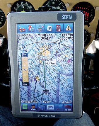 The Septa portable GPS navigator features an exceptionally bright seven-inch touch-screen display due to a custom optical bonding process. |
I've been following Control Vision's Anywhere Map line of products for many years now, and the Septa addresses most of the issues with previous models. Indeed, it may well be the most completely integrated yoke-mount GPS available today.
The Septa measures 7.2x4.8x0.9 inches, and weighs 19.2 ounces when removed from the supplied yoke mount. Its most prominent feature is a matte-finish seven-inch diagonal full-color touch-screen display that's among the brightest I've seen. At full brightness, it's visible in anything short of direct sunlight (you can usually work around that by moving your head). Brightness is controlled by two push buttons on the base of the unit, virtually everything else is done by pressing on-screen buttons.
Unusually for a portable GPS navigator, the Septa comes with a powered yoke mount---and it's one of the best I've seen, strongly built with a ball-and-socket joint and a small cooling fan to keep the Septa working on the hottest days. It's equipped with a standard cigar-lighter plug, and runs on 12- or 28-volt power. Without external power, you can run the Septa on its field-replaceable Li-Ion battery. Control Vision doesn't give a battery-life figure for the Septa, but I found that it still showed a 50% charge after two hours on battery power.
The Septa has a built-in WAAS-enabled GPS receiver, and requires no external antenna (indeed, there's no connector to plug one into), which makes for a very clean in-cockpit installation: Just fit the yoke mount, connect the Septa to it, and plug it into ship's power. I tested it in a Cessna 182P Skylane, and had completely adequate GPS reception.
The software built into the Septa includes Anywhere Map, a GPS moving-map application with flight planning and weather, Pocket Plates, which displays FAA AeroNav instrument arrival/approach/departure plates and airport diagrams, and Via Anywhere, a street-mapping application for use on the ground.
Anywhere Map has been enhanced with new features, including Taxi Express diagrams that show aircraft position on airport taxiways and ramps, rubber-band routing in the flight planner and a built-in flight logbook. The moving map offers view modes including VFR sectional and TAWS-style terrain, IFR en route and approach, weather overlays and a simple emergency view with a patented feature Control Vision calls "cones of safety" that visually shows gliding range to nearby airports. Display refresh is typically once per second, but depends on the level of detail---panning can take some time depending on which view is selected. A feature Control Vision calls Flight Following, described as "a poor man's autopilot," lets you set desired altitude and heading and then generates warnings if you start to deviate. On-screen simulated HSI and RMI instruments are available to assist in navigation relative to one or two selected navaids (or for that matter, any waypoint). Anywhere Map also can help you find low-cost fuel with pricing data from www.100LL.com.
Weather data can be downloaded on the ground using the Septa's built-in WiFi feature. XM satellite weather using an external receiver is one of the Septa's few extra-cost options.
I found the Septa quite usable on a VFR local flight and practice instrument approach near my home airport (KMOD). Fitting the yoke mount and setting up the unit took just a few minutes, and it showed my position on the airport diagram shortly after engine start. One minor annoyance that I found was slow switching between Anywhere Map and the separate Pocket Plates application, which may be an issue for instrument pilots. GPS navigation indications on the Septa matched those from the Garmin 530 in our panel while flying the RNAV(GPS) 28 right approach.
The Anywhere Map Septa sells for $1,495. Annual updates (downloaded directly to the Septa over WiFi or using a supplied USB cable from a desktop PC) cost $195 per year. In-flight weather requires a $700 XM satellite radio receiver and XM weather subscription. For more information, visit www.controlvision.com.


Subscribe to Our Newsletter
Get the latest Plane & Pilot Magazine stories delivered directly to your inbox