

Augmented reality apps, like FlyQ InSight from Seattle Avionics, are just beginning to take off in the aviation world. InSight overlays a view of the real world with data—in real time—just by turning on the mobile app (on either a smartphone or tablet) and pointing the device at the scenery. Using the device’s camera—to show what’s in front of the lens—and its GPS—to provide location information—the app can find airports, show distance and weather information, and even help plan a route and file a flight plan.
All Things Airport
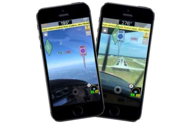
Nearby airports are marked with a tag that extends to their location on the ground, which makes them easy to spot from the air. The tag shows the airport identifier and distance to the field. With a tap on the airport marker, more details pop up.
With all of the airports around, it might sound like the screen could get cluttered pretty quickly. The folks at Seattle Avionics thought of that one too. FlyQ InSight has a variety of filtering tools. It can be set to show airports up to 100 nm away, with a slider that can reduce that distance as desired. It can also filter out airports based on pilot-selected runway length and airport type.
Have a destination in mind? You can search for a specific airport by name, city, state or identifier. Once you’ve selected an airport, the information available begins with all of the stuff you can find in an AFD—like elevation, airport diagrams and frequencies—and adds a lot more, such as fuel prices, current weather, satellite maps and even rental car companies. As a bonus, if any of the facilities at the airport have a phone number on record, InSight lets you call with a tap. The app is easy to navigate and, for anyone worried about having to read tiny text on a smartphone, there are zoom functions built in.
Weather And Wind Information
Airports aren’t the only things InSight has info on. Under the “Weather” tab, you can find current weather information. You’ll be able to access things like radar images, METAR and TAF information, and winds-aloft. Weather maps can be stored for reference for when your device isn’t connected to the internet. You can even use InSight to get a Lockheed Martin or DUAT weather briefing.
In addition to outside weather data, InSight has a feature to help you calculate the winds at your current location. All you have to do is tap the wind calibration button, set the compass dial to match your magnetic compass heading, and select your true airspeed. The app will do the rest.
Flight Planning
The InSight flight planning feature acts as an aid for route planning. The pilot inputs the departure and arrival airports, takeoff time, type of flight and preferred routing, and InSight puts together a flight plan. If you choose, the app will use the wind information from winds-aloft forecasts to suggest the best altitudes.
Once the flight plan is set, InSight automatically requests a weather briefing (Lockheed Martin or DUATS). There’s even a one-tap option to file the flight plan. Lastly, rather than having to re-type the route, InSight can wirelessly transmit the plan to some Garmin GPS units.
There is a lot of depth to this app, and the list of things it can do keeps growing. FlyQ InSight is currently available for iPhone and iPad.
Learn more at Seattle Avionics.