
 |
One of the truly outstanding benefits of shows such as Sun ‘n Fun in Lakeland, Fla., and AirVenture in Oshkosh, Wis., is that pilots have the opportunity to examine and often get some hands-on experience with many of the latest technologies in avionics.
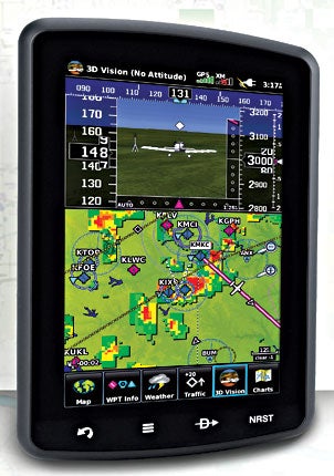
This year, Garmin chose Oshkosh to premiere their new GDL-39 ADS-B receiver. This is a system that currently may be mated to an Apple iPad or Android tablet, plus a Garmin 796. Not too far down the road, it will be capable of mating with the Garmin 696, G3X or aera GPS. The iPad, Android and 796 can all use Bluetooth connectivity, but the other Garmin products will need to be wired directly.
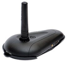
The GDL-39 is a compact unit that may be placed wherever it’s convenient as long as it has a clear view of the sky. That will usually be on the right side of the glare shield. The unit consists of an oblong mounting base and four-inch antenna, and may be powered by direct connection to the aircraft or the system’s own internal Li-Ion battery.
Immediately following EAA AirVenture, Garmin arranged for me to borrow a GDL-39 for a few weeks back in California, and I mated it to my iPad2 via Bluetooth. The iPad2 is a wonderfully talented device as a reference in the cockpit, but it may be too large to conveniently fit in the front office of a typical general aviation airplane. There’s also a problem with display brightness in strong sun. For the purposes of this evaluation, I placed the GDL-39 antenna on the glare shield and simply left the iPad on the right seat of my Mooney.
Before looking at the specifics of the GDL-39, it’s important to understand what ADS-B is and does. The letters stand for Automatic Datalink Surveillance-Broadcast. In conjunction with Communication, Navigation and Surveillance (CNS) technologies, ADS-B is the key to air-traffic management of the future. The FAA has mandated that most ATC functions will be controlled by ADS-B by January 1, 2020.
The worldwide Air Traffic Control system made a giant leap forward with introduction of radar after World War II. As with the prototypes of any new technology, the first radars were still fairly primitive devices by today’s standards, often imprecise and hard to interpret, easily attenuated by weather and other atmospheric anomalies. Beginning in the early 1950s, ATC began maintaining separation with conventional radar augmented by pilot communications, reporting elevation and other information.
What had been the old military IFF (Identification—Friend Or Foe) system gradually gave way to transponders with discrete codes that allowed controllers to pinpoint precise information for specific aircraft. As the system evolved, ATC’s surveillance radar would send out a signal to all aircraft within range, and the transponders would respond. ATC could then determine speed and heading of each aircraft. Eventually, encoders made it possible to add altitude to ATC’s bag of information on each aircraft.
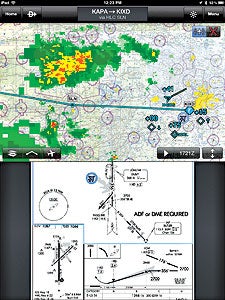 |  The GDL 39 provides portable ADS-B “In” reception for access to traffic and weather on compatible Garmin portables and other mobile devices, such as the Apple iPad, shown here. |
The trouble with radar was/is it’s only modestly accurate. Even on its best day, radar simply isn’t quick enough to stay ahead of the aircraft. A typical radar dish revolves once every five seconds. In five seconds, an aircraft travelling at 440 knots will have moved .7 miles, hardly good enough for accurate control.
Satellite technology was the obvious answer. GPS, the American Navstar satellite navigation system, has a constellation of 24 birds (plus four backups that are normally also operating), orbiting 10,800 miles above the Earth. At any given moment, roughly half those satellites may be within “sight” of your aircraft. GPS has a refresh rate of about five times a second. In other words, it updates its position every fifth of a second. The same 440-knot jet using ADS-B would therefore be sending out position information every 150 feet.
Just as you can use the multiple triangulation signals from so many satellites to establish your position in three dimensions to within a few cubic feet above the Earth, the satellites can do the same thing in conjunction with ATC, coordinate your changing location as you move across the planet, and report that information to the ground. ADS-B operates on two frequencies, 978 and 1090 mHz, and the Garmin GDL-39 receives both of them.
Of course, the new universal GPS-based, all-encompassing air traffic control system introduces levels of complexity undreamed of by most mere mortals. The level of electronic sophistication required to coordinate signals from 24 satellites and thousands of aircraft is a job for extremely accurate computers, part of the justification for delaying full ADS-B implementation until 2020.
The true joy of full ADS-B is that each aircraft broadcasts its position to every other aircraft with an ADS-B transceiver, plus it sends its position to ATC, as well. When the system is fully implemented in 2020, it will represent the best of all possible worlds.
In their ultimate wisdom, the FAA decided one way to encourage everyone to upgrade is to reduce the level of safety for current users. To that end, the FAA is selectively turning off the current TIS (Traffic Information Service) available to owners of mode-S transponders so they can no longer receive traffic alerts. This is supposed to encourage everyone to get on board with ADS-B as quickly as possible.
Like so many other aircraft owners, I was seduced into buying a mode-S Garmin 330 “squitter” transponder in the early 2000s on the premise that I’d have TIS information forevermore.
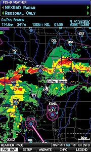 Connecting the GDL 39 with the FAA’s ADS-B weather link, your compatible device, such as the GPSMAP 696, can display subscription-free weather reports and more. |
Not. The feds have already turned off many TIS transmitters around the country and are gradually making it more difficult to operate without ADS-B. For better or worse, I fly in the world’s busiest airspace, the Los Angeles Basin, so TIS in my neck of the sky will probably remain available for a while. It’s nevertheless exasperating that the FAA feels the best way to gain acceptance for ADS-B is to eliminate a current traffic alert system. (Updating a Garmin 330 to the ES configuration to accept ADS-B information is possible for $1,200.)
Unlike radar, the ADS-B signal isn’t attenuated by range, altitude or weather conditions. By definition, an ADS-B position is determined looking down at the Earth from far out on space, so terrain also has little effect on an ADS-B signal.
For those very reasons, the FAA launched a critical test of ADS-B between 1999 and 2006 in Alaska known as the Capstone project. I spoke at the Alaska Airmen’s Association Convention in Anchorage in May 2000, and I had the opportunity to talk to a number of bush pilots who were testing ADS-B for the FAA. Alaska was an ideal location to evaluate the system’s ability to locate and direct aircraft in bad weather and mountainous terrain.
The 49th state has plenty of tall mountains that make standard line-of-sight radar control ineffective for low-flying aircraft. GPS is a look-down technology, however, so it allowed ATC to track an aircraft flying in a mountain canyon pretty much anywhere in the state.
Keep in mind, buying the GDL-39 (roughly $800) won’t allow you to transmit ADS-B information to other aircraft and to Center. The GDL-39 is strictly an ADS-B “In” receiver. It can’t advise ATC or other aircraft of your position. You’ll need an ADS-B “Out” transmitter for that (optional at extra cost).
I flew my tests over two weeks around Southern California, which means I was nearly always within 15 miles of an airliner, either horizontally or on slant range, as they negotiated the busy airspace around LAX, Ontario, Orange County and 14 other airports in the immediate Los Angeles area. Most airliners are already equipped with ADS-B Out transmitters, so I could hitchhike on their signals and read all the traffic they were seeing.
Of course, another major incentive of installing and using ADS-B is free weather information, compared to the subscription fees associated with XM weather (starting at about $30/month). I have XM weather available on my Garmin 696, and it can be illuminating to sit on the ramp and evaluate the weather in Southern California before I take the runway.
Most of the time, you won’t be able to do that with the ADS-B product, because the information is delivered via line-of-sight from the same ground stations that provide TIS. XM is heaven-sent, just like GPS. I departed Compton on one flight with the 696 indicating all the local weather before takeoff; then, watched the iPad weather depiction begin to fill in the screen as I passed through 1,500 feet.
Uncharacteristically, Los Angeles was ringed by thunderstorms dredged up from the Gulf of California, so there was plenty to paint. By the time I passed 3,000 feet, both XM weather on my 696 and the GDL-39 readout on my iPad provided good depictions of the storms, with frightening shades of red and purple scattered across the screens.
There’s little question that ADS-B will provide a major improvement when it’s fully implemented in 2020. In the meantime, it’s frustrating that the government apparently feels it necessary to partially degrade the current system of traffic alerts simply to encourage participation in ADS-B.
GPS With A Russian Accent |
| GLONASS, the Russian equivalent of our GPS, became operational on a limited basis in 1995 and was recently expanded to its full 24-satellite universe in 2011. GLONASS actually offers a few advantages over our Navstar system, but it’s unfortunately not compatible with our cockpit-mounted GPSs.
GLONASS, an acronym for Globalnaya Navagatsionnaya Sputnikovaya Sistema (ask at your next hangar flying session to see if anyone else knows the derivation), does essentially the same job as GPS and offers another 24 satellites with the same navigation features. GLONASS orbits at 11,900 miles, 1,000 miles farther out than our system, and offers a lightning fast refresh rate of 10 times a second, twice as quick as our GPS. That’s position accuracy to about every 35 feet for a 200-knot aircraft. Though GLONASS doesn’t participate in the ADS-B system, Garmin recently produced a wireless receiver to add GLONASS satellite signals for interpretation by your iPad. Put the two systems together, and you have the ingredients for a very comprehensive navigation system that could conceivably provide positional information well beyond that of your standard GPS. Garmin’s GLO receiver was also announced at Oshkosh and has a list price of only $99. Buy the full package, including a cockpit mount, power cables and Garmin Pilot six-month subscription, and you’ll pay $129. Remember, this will only play through an iPad, Android or other laptop computer device, not a standard portable or panel-mount GPS unit. |