 Ask most pilots what subject in aviation they wish they knew more about, and a majority will answer, “weather.” Indeed, while forecasters do occasionally still get it wrong, and even the best meteorologists acknowledge that we still have much to learn, the science of weather prognostication improves each year.
The state of the weather art is often incidental at best or inconvenient at worst to most two-dimensional mortals, but those of us who operate in the third dimension rely on the vagaries of the atmosphere for our very existence.
Enter the age of satellites. Orbiting weather stations have changed the science of both collecting data and transmitting it to the world below. Satellites now can monitor the development of weather systems and provide information downlink service to aircraft equipped for reception. Pilots have discovered that flying with the benefit of near-real-time weather information can transform the way many of us travel.
While it’s still every pilot’s responsibility to obtain a thorough preflight briefing either in person or through a computer link, there are several products that allow aviators to update their information in flight and make more intelligent decisions about where to go if (when) things turn sour.
XM Weather is one of several downlink services on the market (others include Sirius and Iridium). For about $30 per month, you can subscribe to the Aviator LT (Lite) satellite product that provides basic aviation information in flight, i.e., NEXRAD, precipitation type, TAFs and METARs, TFRs, city forecasts and county warnings.
Pilots who are more serious about their weather information can opt for the more comprehensive Aviator package. The price increases to $50 per month, but the products become notably more sophisticated. In addition to all the items detailed above, XM’s Aviator subscription includes information on AIRMETs and SIGMETs, lightning, echo tops, freezing level, storm tracks, surface analysis WX maps, Satellite Mosaic, AIREPs and PIREPs and, perhaps most valuable of all to every pilot, winds aloft. Predictably, this is the most popular subscription.
Finally, the full Aviator Pro package sells for $100 per month, and that includes a number of new features, primarily but not exclusively for the professional pilot flying under IMC who needs maximum info. The additions are turbulence (in 3,000-foot increments), current icing product (in five levels of severity from 1,000 to 30,000 feet), supercooled water droplets (freezing drizzle or rain to 30,000 feet), SPC (Storm Prediction Center) convective outlook, mesoscale discussions, visibility (in one-mile increments less than 10 miles) and hurricane track. If you wish to add entertainment to the weather products, you can do so for under $10 per month and choose from 170 channels that will provide everything from jazz and classical music to rock and rap.
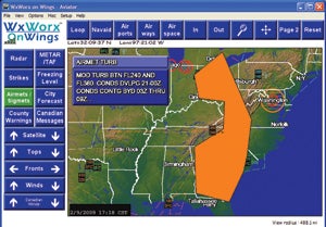 WxWorx on Wings displays AIRMET information from XM WX Satellite Weather |
The information is collected from numerous government and commercial sources by WxWorx, a major supplier of weather information. As suggested above, the weather products offered vary from simple to incredibly comprehensive. Update rates vary with each product, depending upon availability of new information, but the refresh rate can be as little as five minutes.
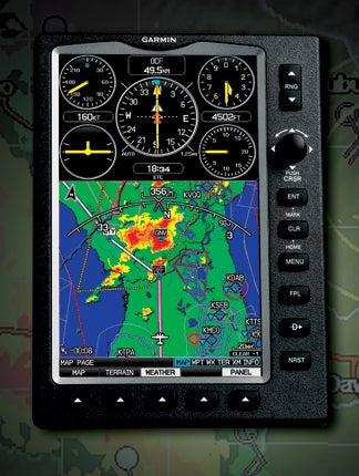
A complete description of all the available data types listed above would consume most of the magazine, but most of the system’s products are self-explanatory. A great deal of flexibility is provided in the display of XM products. They can be displayed on a variety of GPS screens, MFDs, EFBs and even pocket PCs. Pilots can either use FAA-certified or portable receivers, so they can employ the system as an integrated component of their cockpits or as portable, plug-and-play additions.
Satellite transmission has the advantage of being relatively impervious to atmospheric anomalies. Even heavy rain, hail or major atmospheric disturbances won’t interrupt the transmission of XM Weather, no matter what the product. In total, there are 19 data categories available, enough to keep pilots engaged and well-informed about what lies ahead.
All this sophistication might suggest that XM Weather is only for drivers of high-ticket turbine equipment, but that would be far from the truth. In some respects, the XM Weather products are even more appropriate to low-altitude operation, where weather can be more dynamic and have a greater impact on the safety of flight. XM’s information isn’t just for aviators flying in the clag. You don’t have to be a hard-core instrument pilot to appreciate the benefits of XM.
Perhaps the most obvious and valuable VFR application of the system is the winds aloft page. There are several wind tricks that can come to the rescue of pilots and their wallets in a number of situations.
A few months back, I was delivering a Marchetti SF.260 some 5,500 nm from Santa Monica, Calif., to Coventry, England, and elected to take along my Garmin 396 with XM Aviator coverage. I knew my coverage would only work in the continental United States and southern Canada, but that still represented nearly half of the distance to be traveled. XM’s two satellites (idiosyncratically named “Rock” and “Roll”) are parked in geosynchronous orbits above North America’s East and West Coasts, so the service is tailored primarily for the United States. It does extend several hundred miles into Canada and Mexico, however, and I knew I’d benefit from the system for the first 400 miles into Canada.
 Using a Garmin 396 with XM Aviator coverage, Bill Cox ferried a Marchetti SF.260 across the North Atlantic |
While most of my international flying is done on IFR flight plans, the first 3,000 nm of this trip was diagonally across the States from Southern California to Bangor, Maine, and on to Goose Bay, Labrador. The weather was great for the first 1,800 miles, so I flew VFR, with help from the XM Weather wind page. (Later, when the weather turned sour and I was forced to follow a set route, I used the wind pages for updated flight planning.)
XM’s wind information is graduated in 3,000-foot increments all the way to 42,000 feet, and that helps you answer a major question. You’re no longer required to invest the time and fuel to climb to a higher altitude in the hope that the wind will be more favorable. If it isn’t, you may have lost time and expensive avgas in the climb only to have to descend back to your original height. With XM, it’s no great trick to check wind at all higher altitudes right up to the airplane’s service ceiling, even prior to the flight on the ground.
In the case of the Marchetti, the optimum height for cruise is about 8,000 feet, close enough to the 9,000-foot wind chart. Before takeoff, I checked the winds at all heights to estimate the best altitude to optimize speed and minimize fuel burn. In some instances, higher was better, even if it was slightly slower, because fuel burn was disproportionately reduced. I knew I’d realize significantly better nautical mpg. I was on a fixed-price contract, of course, so fuel economy was more important, a simple matter of profit and loss.
Perhaps even more useful than the pure altitude pages, however, is the fact that if your trip is a long one, as mine was, you can go to the larger scale and determine if you should use different altitudes for different sections of the trip. Too many pilots are in the habit of choosing a specific altitude and sticking with it for the entire trip. That may be convenient, but it won’t always optimize the airplane’s performance. You obviously want to avoid pogoing through the sky as you travel, but there’s no sin in choosing the most efficient height as conditions change.
Another possible VFR benefit of the wind pages is that you can actually use them to change your route slightly to take advantage of pressure patterns. At the higher ranges on a Garmin 396 and 496, and especially on the new, larger 696, you can display wind trends well to the left or right of course, allowing you to preplan a slight deviation if it will reduce the time en route. This won’t have much application on short trips, but if the leg is longer than, say, 600 nm, you may be flying adjacent to a number of weather systems, and a deviation may make sense.
Remember that the shortest distance between two points is less important than the shortest time between those points. The Marchetti burns about 14 gph at max cruise down at 8,000 feet, but there were times when it became obvious the better choice was to climb to 11,000 or even 13,000 feet and fly slower at 65% or 55% power to realize better winds and significantly improved fuel burn.
There was a time when limited weather information was only available on the ground before a flight. Then, the industry transitioned to offer availability of atmospheric conditions through radio communications with the ground. Today, satellite technology has allowed XM Weather to bring a variety of products right into the cockpit, so a pilot can analyze and interpret conditions ahead and make informed decisions on where and when to go…or not. The bottom line is safety, and the satellite information offered by XM helps ensure a safer flight.


