
 The Great Rift Valley is one of the biggest and most remarkable fault zones in the world. It stretches more than 3,500 miles and is recognizable from space. Tectonic movements have created high mountain rims that play host to moist tropical rainfall. The fertile volcanic earth supports diverse plant and animal life. It's here in this "Valley of Life" that the earliest human remains were discovered.
In light aircraft, flying low at moderate airspeeds, the landscape changes faster than man's memories. This new perspective takes you away from accepted understanding, observation and thinking. In the air, you become a detached witness to all that occurs on the earth's surface.
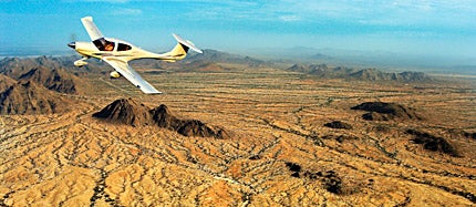
Overflying the Nile River---from its delta in the Mediterranean Sea to its springs above the Great Rift Valley---is like a dream. The Diamond Star DA40 TDI is one of the most suitable airplanes for this purpose. Its diesel engine runs on Jet A, which can be bought at almost every airfield in the world. Beside me in the right seat, Joseph, the cameraman, uses sophisticated digital equipment to record the events passing under our wings. In 21 days, we have flown 17,800 kilometers, as low as 300 feet AGL and as high as FL185.
This beautiful journey, however, has posed many challenges. We've needed permits for visual flights, which have sometimes proven difficult or impossible in several countries where foreign aviation is restricted due to military presence, ongoing wars, rebellions and corrupt bureaucracies. Africa's diverse climate can define limits as well, and it can be problematic establishing the most favorable season for flying. October seems promising, and although the rainy season in Sudan can last until November, the visibility above desert areas should be better than in the summer months.
The Nile River is like a phantom in the desert, an irrational error in the natural ecosystem. It winds for 6,680 kilometers, carrying millions of tons of fertile earth from the Ethiopian mountains and the Sudan tropics. However, only a few hundred meters from the flow, nothing survives under the desert sun.
The morning above Aswan is majestic. A huge fiery ball slowly ascends above the horizon and is reflected in Nasser Lake. Abu Simbel, one of Egypt's most impressive monuments, which is decorated with statues of Pharaoh Ramses, almost slips unnoticed beneath us. Patiently, I radio air traffic control in Khartoum, 800 kilometers in the distance. Without contact, I can't be sure that they're expecting us. Flying at low altitudes over a high density of war machinery creates some unease.
 |
| In a Diamond Star, Matevz Lenarcic flew more than 11,000 miles tracing the Nile River over Africa's Great Rift Valley. |
South of Khartoum the desert starts to change. Around volcanic peaks surrounded by sand dunes, the first bushes appear. Their density increases and, gradually, the parched brown trees in dry riverbeds become green. This signals our approach to the rain-rich tropical belt. Here the Nile lazily twists around green grass and low bushes. No animals can be seen, but now and then we overfly lonely villages with round clay and straw cottages.
The clouds are descending toward the marshes and they take us with them. For some time it looks fine, but then we find ourselves in the middle of a grey mist in IMC. Airliners flying from south of Sudan warn of heavy thunderstorms. Because the aircraft isn't equipped with weather radar, I turn back to Malakal, a village on the Nile.
In order to reach Juba, a town in southern Sudan, one must fly three hours over one of the world's most remote areas. Deep swampy rain forest stretches more than 1,000 square kilometers in every direction. Toward the middle of the flight, the clouds beneath us start to break, and the twisted riverbed of the Nile comes into sight. The marshes act as a big sponge that accumulates enormous quantities of water, thus influencing the river's flow and enabling it to survive to the Mediterranean Sea.
Before the Nile flows through the Imatong Gorge to Uganda, we turn east to the Great Rift Valley. Through the morning's cold, our wings glide softly toward Lake Turkana. As the light intensifies, ground objects throw their first shadows. Dry riverbeds are covered with green bushes and rare trees, and it's obvious that underneath the surface, water still runs from the hills. On confluent points, the flora becomes richer, and with it, people come into the picture. Round villages with branch fences are clones of each other. People dressed in lively colors walk between dogs and goats. Occasional cowherds are accompanied by tall shepherds leaning on long sticks.
The following day, cloud cover is quite high; it seems an eternity before we climb over it. Up above, the snow on Mount Kilimanjaro reflects sunlight into the clear air. We follow its south wall, covered with glaciers, toward Kibo and Mawenzi, its volcanic neighbors. Unfortunately, the weather beneath us is rapidly getting sour, and the holes in the clouds are becoming sparser. We decide to proceed west over the lunar landscape of the desert, where water is replaced with colorful dried mud. The ground must be really hot---the heavy turbulences make us feel as if we're in a washing machine.
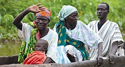 |
| Although Matevz often encountered difficulties obtaining permits for flights, his trip was a most remarkable experience. |
In the distance, lights reflect Lake Victoria, the spring of the Nile. We have arrived at the mouth of the river that created civilizations and then witnessed their rise and fall. Ngorongoro Crater is shrouded in clouds so we fly over and decide to descend at Tarangire National Park, spiralling through a small gap. As we proceed over wide Masai grassland toward the shores of the Indian Ocean and Zanzibar, the weather deteriorates.
In a few days we find ourselves again in Kenya. Lake Turkana, the biggest desert lake in the world, receives its water almost entirely from the Omo River that springs from Ethiopia. From here, the Valley of Life stretches northeast to Addis Ababa, Ethiopia's capital. We wish to go north to Tana Lake, but our hopes are downed by military demands that we take soldiers on board to supervise the flight. Because the airport is 2,400 meters above sea level and the temperature is 25-degrees F, we'd need to take off in 4,000 meters. We were already at our limit with two on board.
Because of war, direct flight to Eritrea isn't possible, and Djibouti is the only way to the Red Sea. To the northeast, we follow a 1,000-meter rift, whose cultivated fields remind me of terrace fields in Nepal. Flights like these, between the Egyptian coasts of the Red Sea and the Mediterranean Sea, are scarce in any pilot's life. The 2,000-meter peaks of the Arabian Desert shine in the early sunlight as we glide in cold air over steep gorges. We feel no turbulence. Quietly we sit in the cockpit, hoping not to disturb the natural balance. Even the engine noises stay out of our consciousness, and it seems that everything has found its place. "This is close to perfection," says Joseph, and I can only nod.


Subscribe to Our Newsletter
Get the latest Plane & Pilot Magazine stories delivered directly to your inbox