
One of my roles in life seems to be “The IFR Answer Guy.” Sometimes, I can toss off the answer as a one-liner between sips of morning coffee. Other times, I’m left scratching my head until I delve deep into the IFR minutia.
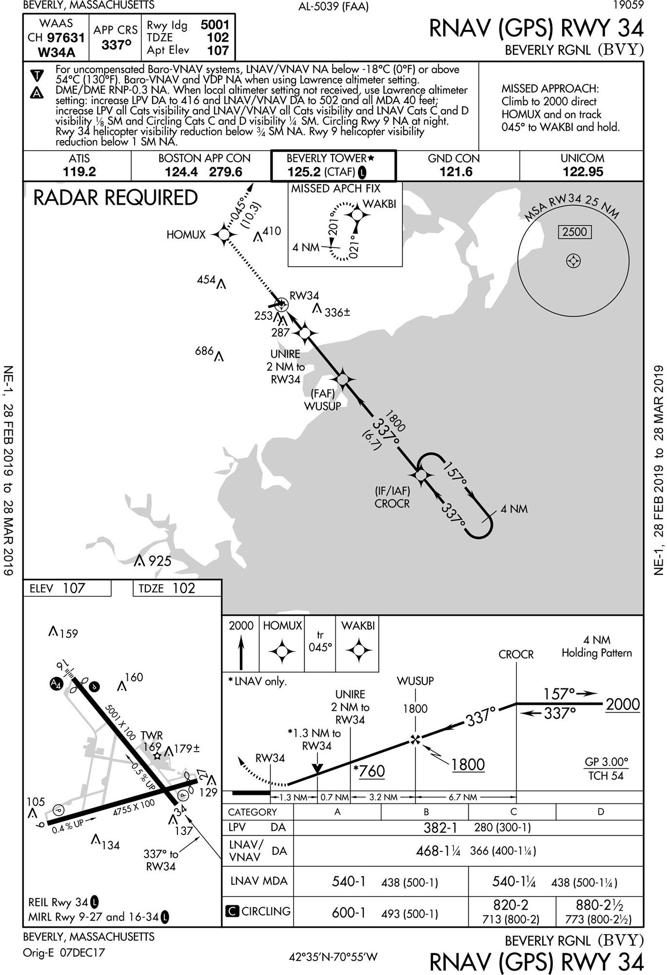
That’s what happened with what seemed like a simple question about the RNAV (GPS) Rwy 34 approach at Beverly, Massachusetts (KBVY). The query was, “Why is radar required?”
The answer requires a bit of theory. Chart design for IFR assumes the pilot will navigate the entire flight, from takeoff to touchdown, without any assistance from air traffic controllers (ATC). That means there must be some kind of connect-the-dots method of going from chart to chart by using a fix appearing on both charts. This almost never happens in practice because ATC steps in and vectors airplanes as needed, but the charts must allow some possible way for this to happen—or carry a note that it cannot.
“Radar Required” appears in the plan view of an instrument approach chart when there’s no way to navigate from the en route structure (a.k.a. airways) to any initial approach fix (IAF) without the help of a kindly controller. The most common reason for this is that the approach has no IAF. Such approaches require ATC vectors to the intermediate fix (IF) or onto the final approach course.
That’s not true on the KBVY RNAV (GPS) Rwy 34. CROCR serves as both IAF and IF. You could cross CROCR from any direction, fly a hold-in-lieu-of-procedure-turn, if needed, and head inbound. (As an aside, I want to fly this approach just to check in with Tower at the FAF of WUSUP by saying, “Beverly Tower, Cessna One Two Thee Alpha Mike, RNAV Runway 34—Wuzzup?!”)
Sometimes radar is required because the IAF, or a fix that starts a feeder route to the IAF, isn’t depicted on the en route chart. That means there’s no connect-the-dots and ATC must step in. That restriction doesn’t apply to RNAV waypoints, however, so that’s not the reason for “Radar Required.” In fact, that’s what’s so odd about any RNAV approach requiring radar. You must have RNAV to fly this approach, so you must be capable of flying direct CROCR from any nearby airway. You could fly direct CROCR from Kalamazoo if you wanted. Why do you need ATC radar?
The answer comes in the form of another question: What altitude would you fly to CROCR? Remember that you must be able to fly it without assistance. Many charts have transition routes, which show a heading and altitude to fly from a fix in the en route structure to the IAF. The RNAV (GPS) Rwy 16 approach to KBVY has one from the Pease VOR of 3000 feet on the 213 radial. There are no transition routes to CROCR.
Some RVAV approaches have a Terminal Arrival Area, such as the KLEW RNAV (GPS) Rwy 4 approach. This system provides altitudes for entire quadrants. If you’re approaching within that quadrant, once you’re within 30 miles, you have an altitude to fly as you proceed direct to the fix. There are no such quadrants heading to CROCR.
There’s no published altitude anywhere for flying direct CROCR—and that’s the reason it says “Radar Required.” ATC must see your position on radar in order to assign the appropriate altitude until reaching CROCR.
There is a Minimum Safe Altitude (MSA) on the chart. In case you’ve forgotten, the MSA covers a radius from some fix on the approach and denotes an obstruction-free altitude. In this case, it’s a 25-NM radius from the missed approach point of Runway 34. You know that by the text curving around the MSA circle: “MSA RW34 25 NM.”
MSAs are for emergency reference only. They’re for when everything goes to hell, you’re off course and just need to get to a safe altitude and regroup. MSAs don’t even apply to lost communication unless they’re higher than your last assigned altitude and you’re flying off-route within the MSA radius. If you were direct KBVY and told to expect this approach, and then you lost communication, you’d maintain your last assigned altitude until crossing Beverly Airport, maintain that altitude to CROCR, and only then descend in the HILPT and commence the approach. For RNAV approaches with terminal arrival areas, no MSA is published. It would be superfluous. You simply use the quadrant altitudes in lieu of an MSA.
This discussion gets more curious when you look at the KBVY RNAV (GPS) Rwy 9 approach. This approach has two IAFs, one at COLLE and another at RIKAH. COLLE shows Radar Required for the same reason CROCR did. It also shows a minimum crossing altitude of 2000 feet. That’s really odd because, if radar is required, you’d only arrive at COLLE on a vector or direct-to from ATC. Such a vector would include an altitude to maintain. The segment from COLLE to EXXRO is also 2000 feet, so you wouldn’t descend after COLLE. I asked my FAA contact about this, and according to them, it might have been an error or a request from ATC when the approach was created, though that dodges the question.
RIKAH is a different matter. There is no requirement for radar—even though this is an RNAV fix sitting in space like COLLE or CROCR. The 3000-foot crossing restriction here makes sense because without a radar requirement you might be choosing your own altitudes. The segment from RIKAH to EXXRO has an MEA of 2000 feet, but you can’t go below 3000 until after crossing RIKAH.
To see what’s special about RIKAH that it doesn’t require radar takes some more chart hopping. In this case, the reveal happens with the DREEM TWO and ZELKA TWO arrivals. RIKAH is depicted on both these charts. This provides a path from the en route structure complete with MEAs for each segment. A pilot could fly a complete route from en route through arrival to approach without any information required from ATC or radar contact. That’s presuming said pilot did all the document searching to figure out how the dots connected.
The takeaway from this is our IFR system is truly an integrated system. Individual pieces, such as an approach chart, might make no sense out of context. This chart coordination can create issues. My query about these approaches revealed to my FAA contact that RIKAH has a mandatory altitude of 6000 and speed of 210 knots on the ZELKA 2 but not on the adjoining approach. This can cause FMS systems on turbine equipment to simply disconnect. It will be fixed. (All you flying jets into Beverley can thank me just like you did the guys on “Car Talk.” Write your note on the back of a $20 bill…).
Then again, in the real world this discussion might be entirely academic. If I were expecting the DREEM TWO arrival and went lost comm, or a failure of ATC radar meant the other approaches at Beverly were not available, I could fly the RNAV (GPS) Rwy 9. However, if conditions favored another runway, I might invoke emergency authority and MSA my way over to a more favorable approach.
Or I’d simply go elsewhere. There are times the lack of official blessing on one little number breaks the whole system.